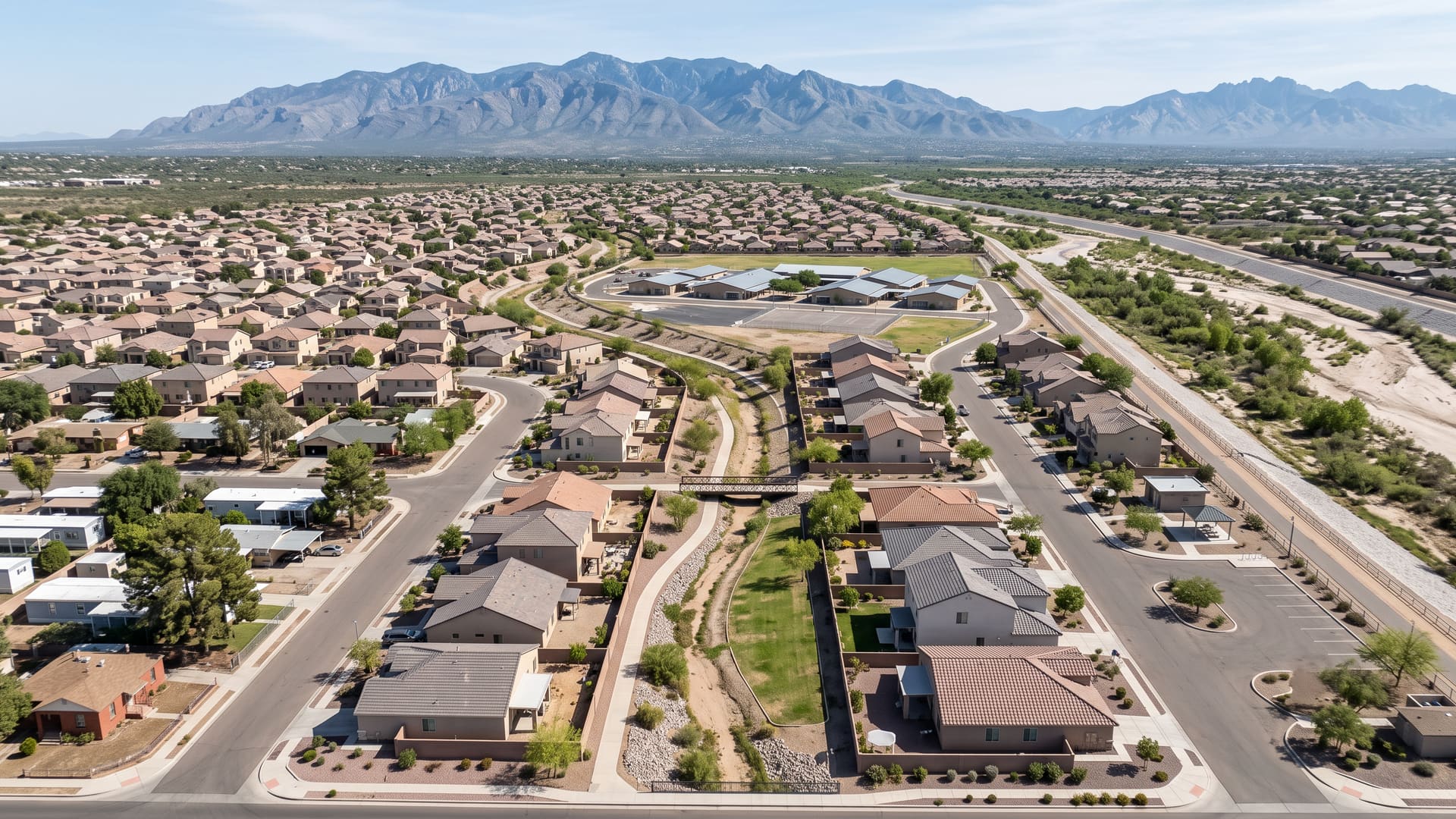
Rillito Homes for Sale — Tucson, AZ
All fifty-eight of the last homes to sell inside this line were detached houses — not one townhouse, not one condominium, in three years of closed sales. The reason is that a single subdivision recorded in October 2002 accounts for most of the ground.
Key facts
- Jurisdiction
- Tucson, Arizona — incorporated city, Pima County
- Average sale price
- $370,000
- Price range
- $250K – $450K
- School district
- Tucson Unified (Davidson Elementary, Doolen, Catalina High)
- Approximate population
- ~1,400
- Approximate number of homes
- ~730 homes
What defines this area
- Detached houses on all 58 closings, with no attached sale on the record
- Rillito River Park and the Loop path along the whole northern edge
- A $370,000 median across 58 closings in three years
- The Riverhaven trailhead, with 31 bays, a ramada and a restroom
- One 2002 plat of 373 lots, plus 54 more in 2004
- Build years running 1956 to 2005, with a 2003 median
- Davidson Elementary inside the line, the only school in it
- Fort Lowell Road south, Alvernon Way west, Columbus Boulevard east
- The south bank of the Rillito as the northern boundary
- Rillito River Side Acres, 72 lots recorded in March 1929
- An HOA on the 2000s plats and none on the 1929-1955 grid
- Floor area, not build year, as the axis price moves along
- Eight zoning districts, R-2 over seven-tenths of the parcels
- 587 county parcels, every one City of Tucson
- A FEMA Zone AE corridor with no residential parcel inside it
- Annexed in three acts between 1970 and 1990
- Thirty-two street names, and the 2000s ones all name water
- Ward 3, ZIP 85712, about 5.2 miles north-east of downtown
About Rillito
All fifty-eight of the last homes to sell inside this line were detached houses — not one townhouse, not one condominium, in three years of closed sales. The reason is that a single subdivision recorded in October 2002 accounts for most of the ground. Over the three years to October 2026 those fifty-eight closings ran from $212,000 to $555,000 around a median of $370,000, and because they are all the same housing form and very nearly all the same age, price here tracks floor area and almost nothing else. The boundary is about 209 acres of central-east Tucson — roughly a third of a square mile, dead flat, almost entirely ZIP 85712 — and three of its four edges are streets while the fourth is a river. East Fort Lowell Road closes it on the south, North Alvernon Way on the west and North Columbus Boulevard on the east for the southern two-thirds of that side; the north and north-east edge follows the south bank of the Rillito River, within about ten to fifty metres of the channel the county maps. Pima County classifies Fort Lowell Road and Alvernon Way as major local roads and Columbus Boulevard as a minor local one, so this is two major-road edges, one minor-road edge and a river. The Rillito here is at its head: it forms about 1.7 miles east of this boundary where Tanque Verde Creek meets Pantano Wash, which is the confluence the Fort Lowell neighborhood — a separate page on this site — was founded on. Prince Tucson, which also has a page here, is the bend in the same river a mile and a half west. The recorded plat history is short and very lopsided. Pima County records eight plats touching the line and seven lying wholly inside it, and they fall in two groups separated by forty-seven years. The first group is detached, old and small: Rillito River Side Acres, 72 lots, recorded on 8 March 1929; Deseret Heights, 27 lots, in April 1952; and Green Valley Addition, 37 lots, in September 1955 — an Addition platted in Tucson in 1955 and no relation to the Green Valley about thirty miles south that has its own page here. The second group is the neighborhood as it now stands. Riverhaven recorded 373 lots on 23 October 2002 and Walnut Property another 54 on 1 July 2004, and between them they are 430 of the 587 county parcels wholly inside this line and 424 of the 486 that carry a residential use code. Nearly nine in ten homes here were platted inside a twenty-one-month window. Three later plats are not housing at all: Rillito Crossing, Blocks 1 and 2 in July 2003, then Rillito Crossing Corporate Centre's 42 commercial units in February 2005 and Puente Nuevo Plaza's 25 in June 2008, together 62 parcels and not one of them residential. One detail is worth naming because it tells you what survived: not a single parcel inside this boundary carries the 1929 plat's name in its legal description. The thirty-two parcels the county still describes by metes and bounds — portions of lots in Section 27 — are what became of those 72 lots, so the oldest plat here is the one whose lot lines no longer exist on paper. Here is what the market actually did. All fifty-eight closings were single-family detached houses. They were built between 1956 and 2005 with a median year of 2003 and an average of 1996, ran 980 to 2,942 square feet with a median of 1,654, and closed at a median $220.65 per square foot across a $158.30 to $301.29 range. Sorted into price bands, the record puts 1 closing under $250,000, 12 from $250,000 to $300,000, 10 from $300,000 to $350,000, 22 from $350,000 to $400,000, 7 from $400,000 to $450,000, 1 from $450,000 to $500,000 and 5 above $500,000. Median floor area climbs with the money almost without a break — 1,212 square feet, then 1,212, 1,445, 1,855, 2,002, a single 1,921-square-foot closing out of order, and 2,609 at the top. Median build year does not climb at all: it sits at 2003 or 2004 in every one of the seven bands. On this ground you are not choosing between decades at different prices, which is what most of central Tucson offers; you are choosing between sizes of the same early-2000s house. Price per square foot runs in no direction across the bands at all — $174.92, $242.99, $220.76, $210.24, $221.24, $234.25, $197.39 — and the dearest square foot in the boundary is in its second-cheapest band, because these are small houses, so nothing should be read from that ordering. The range printed at the top of this page is drawn around the body of the record rather than its ends: 51 of the 58 closed between $250,000 and $450,000, one below and six above. These are closed sales, not homes currently for sale. Whole-record figures, for completeness. List price ran $230,000 to $565,000 to a $374,950 median, and original list price to a $377,450 median. The median listing went under contract 43 days after coming to market and took 50 days from contract to close, with a median 24 days on market against 34 cumulative, a 0.98 sale-to-list ratio, 5 of the 58 closing above asking and 21 taking a price reduction first. Days on market rest on 56 of the 58 records rather than all of them. The top band is the quickest: those five closings above $500,000 recorded a median 2 days on market and not one price reduction between them. Homeowners associations are a straightforward question here, which is not usually true of a Tucson neighborhood page. Riverhaven Community Association, Inc. is an Arizona nonprofit corporation serving as the property owners' association for Riverhaven as a planned community, under a Declaration of Covenants, Conditions, Restrictions and Easements dated 2002 — the same year as the plat. Its own published bylaws are the source for that; the copy posted by its management company leaves the recording docket and page blank, so read the recorded Declaration itself out of the title work rather than from any summary, including this one. The association's own website describes 13 acres of common area and, as its principal amenity, a long walking path that follows the Christopher Wash through the neighborhood and ends at Rillito River Park. Pima County's trail layer corroborates the arrangement from the other side: four of the nine trail access points inside this boundary are recorded as neighborhood access maintained by an HOA rather than by the county. No dues or assessment figure is published anywhere this page can verify, and the City of Tucson layer that used to publish a register of homeowners associations is no longer in Pima County's open GIS catalogue, so no fee is stated here — get the resale disclosure package and the current assessment in writing before writing an offer. The 1929, 1952 and 1955 plats carry no such dedication anywhere in the county record, so treat a house in the old south-west grid as likely to carry no association and anything in Riverhaven or Walnut Property as very likely to carry one. The association called Montezuma is a different thing again: a voluntary neighborhood association registered with the City of Tucson, active, in Ward 3, with bylaws adopted on 7 April 2024, no assessment power and no covenant authority over anyone's title. It is also small — 12.3 acres, of which 99.4 per cent lies inside this boundary, but which covers only 5.9 per cent of it. Unlike several neighborhoods on this site, this line is not a registered association's outline. It is a data boundary named for the river on its northern edge. The river is the thing to read carefully before buying here, and the honest answer has two halves that point opposite ways. The hazard is real and it is mapped. Pima County records four reaches of the Rillito inside this boundary in its major wash network, every one of them in the over-ten-thousand-cubic-feet-per-second class, with banks of soil cement and of natural soil and cement together, and the county attaches a 500-foot standard setback to that channel. Three smaller washes are mapped inside as well — Alvernon Wash on the west edge, over two thousand cubic feet per second behind soil cement with a 100-foot setback; Valley View Wash at 3,514 cubic feet per second between natural banks; and Christopher City Wash, under five hundred, with a 25-foot setback — along with one short unnamed reach also carrying a 25-foot setback. FEMA's digital flood map draws a special flood hazard area inside this line rather than none: Zone AE covers 17 of 64 interior sample points and a sliver of Zone AH reaches the boundary, with a mapped regulatory floodway over 9 of the 64, the remainder splitting between Zone X and the shaded Zone X that marks the 0.2 per cent annual chance band. Two FIRM panels cover the ground, 04019C1693L and 04019C1694L, both effective 16 June 2011. That is the first half. The second is that the houses are sited off it. Of the 587 county parcels wholly inside this boundary, 22 have their centroid inside a special flood hazard area and 7 inside the floodway — and of the 486 parcels carrying a residential use code, not one falls in either. The flood-zone land is the river corridor itself, which is zoned and held differently from the housing: eight parcels zoned SR, the City's suburban-ranch zone for very low density large-lot development in which uses that would adversely affect open space or natural characteristics are not permitted, account for 30.9 of the 126.8 parcel acres here on their own. A centroid test is not a flood determination for any particular address, and a setback is measured outward from the mapped channel rather than from a lot line, so whether either reaches a given property is a question for an elevation certificate, a survey and a title search — but the pattern in the record is that the corridor is open land and the subdivision sits behind it. The county also rates Fort Lowell Road, the southern edge, as passable during moderate storms. What the river gives back is open space inside the boundary rather than over one of its edges. Rillito River Park, Pima County's linear park along the channel, runs the whole northern edge: the county records 47 of its trail segments inside this boundary, hard-surfaced at eight to twelve feet and soft-surfaced at eight to fifteen, open to pedestrians, cyclists, dogs and horses and marked as accessible, and describes the park as running from Interstate 10 east to Craycroft Road on both banks, as part of the roughly 140-mile Chuck Huckelberry Loop. Nine trail access points stand inside the boundary. One of them is a full trailhead, maintained by the county and named Riverhaven: 31 marked parking bays and one accessible bay, a restroom, a drinking fountain, a ramada and picnic tables. Three more are public access points at Paradise Falls and one at the Alvernon Way south bank; the remaining four are the neighborhood access points on the Rillito Crossing side. Rillito Crossing Linear Park, two-thirds of an acre dedicated to the City by the 2003 plat, sits inside as well, and the association's website notes that the 60-acre Swan Wetlands restoration project, dedicated in the autumn of 2008, lies across the street from the north-eastern corner. Brandi Fenton Memorial Park is about nine-tenths of a mile away and Fort Lowell Park about two miles east. Zoning is the next thing to check before planning anything. Every one of the 587 parcels wholly inside the line is under City of Tucson jurisdiction with no unincorporated pocket anywhere, all in one tax area, on 126.8 acres — so roughly eighty of these 209 acres is street right-of-way, drainage and river channel rather than taxable lot. Eight zoning districts appear. R-2, the City's medium-density residence zone, covers 414 parcels on 54.3 acres and is the zone Riverhaven and Walnut Property were built under; the code gives its purpose as medium-density single-family and multifamily residential development alongside the schools, parks and public services an urban residential environment needs. R-1, the urban low-density single-family zone, takes 85 parcels on 14.0 acres, and RX-1, its suburban low-density equivalent, three on 2.5. C-1, for low-intensity commercial uses compatible with adjacent residential ones, takes 61 parcels on 12.4 acres along the Fort Lowell Road frontage, with C-2 on five more. MH-1, the mobile home zone, covers ten parcels on 4.6 acres, and R-3, the high-density residence zone, a single 4.5-acre parcel. Measured by area rather than by parcel the ranking inverts — SR leads at 25 of 64 interior sample points against R-2's 24 — because the river corridor is large and barely subdivided. Current zoning matched original zoning at every one of the 64 points. Read all of it as what the ground is permitted to hold rather than as an account of what stands on it, and note that Tucson's middle housing amendment, adopted on 16 December 2025 and effective 1 January 2026, widened what is allowed again. Three development plans are on file. The largest by far is Heather Village Apartments, 152 units approved on 31 October 1986, which is why the census counts far more dwelling units here than the county counts residential parcels. Puente Nuevo Plaza's 22 units followed in November 2007. The city arrived here in three acts and none of them matches the housing. Ordinance 3376, effective 30 January 1970, covers a fifth of the interior; Ordinance 3620, effective 5 May 1971, a quarter; and Ordinance 7511, effective 20 December 1990, the largest share, with no deannexation anywhere. Two further ordinances intersect the boundary and reach none of its interior. So the 1929 plat was laid out as unincorporated Pima County and preceded the city here by forty-one years, while Riverhaven — the plat that is now most of the neighborhood — was drawn twelve years after the last annexation, inside city limits and under city code from the start. That is the opposite sequence to most of central Tucson, where the plats came first. Schools are Tucson Unified throughout, and the assignment is uniform at all three levels rather than splitting at one of them. Pima County's attendance-area polygons return the same three schools at every one of 64 interior sample points: Davidson Elementary School at 3950 East Paradise Falls Drive, Doolen Middle School at 2400 North Country Club Road and Catalina High School at 3645 East Pima Street. Davidson is the unusual part — it stands inside this boundary, on one of the subdivision's own streets, less than two-tenths of a mile from the middle of the line, and it is the only school of any kind the county records here. The other two are about 1.8 and 1.9 miles away. The county and LiveBy disagree on the grade ranges at two of the three, so none is stated here. Assignments are drawn by address and they change, so confirm a specific address with the district rather than with a neighborhood map. One record that is empty on many Tucson pages is not empty here. Pima County maps this boundary inside the Davis-Monthan Air Force Base Vicinity, at 55 of the 64 interior sample points — Arizona Revised Statutes section 28-8461 defines that territory for Davis-Monthan as reaching six and a half miles north-east of the runway centreline, and section 28-8484 requires a seller of residential real estate in territory in the vicinity of a military airport to give the buyer a written disclosure before title transfers. The statutory trigger is the State Land Department's map rather than the county's layer, so treat this as a disclosure to expect in the transaction and confirm rather than as a determination made here. The eight other airport layers the county publishes return nothing anywhere inside the line, and all nine were checked against features over Davis-Monthan, Tucson International and Marana Regional first, so those eight zeros are findings rather than missing data: no Davis-Monthan noise control district, no air installation compatible use zone, no avigation easement or disclosure area, and none of the three Airport Environs height, land use or noise overlay zones. There is no National Register historic district inside the boundary, no buffer or infill overlay zone, and no police station or post office. The nearest fire stations are Tucson Fire Department 5 and 7, about two miles south-west and south-east. The rest of the record. The county addresses 547 official address points inside the boundary across 32 street names, and the naming is the clearest signal of what this place is: Wading Pond 39, Sierra Springs 38, Babbling Brook 36, Boulder Springs 35, Deer Dancer 32, Sapphire Falls 32, River Rapids 26, Pebble Rapids 24, Surging Waters 22 and Rambling Creek 22 lead the list, every one of them a 2002 or 2004 street named for water, while the old grid's Sycamore, Montezuma, Lind, Hardy, Deseret, Longfellow, Walnut and Columbus together account for fewer than seventy. All but three of the 547 are ZIP 85712. The whole boundary is in Ward 3. Eleven City of Tucson property records sit inside: three undedicated drainageways along Alvernon Way acquired in 1980 and 1981, a Tucson Water wellsite in the 1952 plat, the Rillito Crossing linear park, four houses held by Housing and Community Development, three of them bought from the Riverhaven builder between 2000 and 2003, and two parcels since sold. Measured from the middle of the boundary, Davidson Elementary is under two-tenths of a mile, Brandi Fenton Memorial Park nine-tenths, Doolen Middle 1.8 miles, Catalina High and the Dusenberry-River library 1.9, Tucson Medical Center and Fort Lowell Park about 2.0, Banner-University Medical Center Tucson 3.2, the University of Arizona 3.9, Park Place 4.2, Tucson Mall 4.2, downtown Tucson 5.2 and Tucson International Airport 10.6.
Rillito is a suburban neighborhood in the City of Tucson, on the central side of metro Tucson, Arizona, served by Tucson Unified (Davidson Elementary, Doolen, Catalina High). Homes trade in the $250K – $450K range, with an average sale price of $370,000 across roughly 730 homes and a population of about 1,400. Kyle Berglund, REALTOR® at Tierra Antigua Realty, represents buyers and sellers here — call (520) 250-8904.
Compare nearby Tucson neighborhoods
- Fort Lowell — Urban, average $489,000
- Prince Tucson — Urban, average $404,000
- Vail — Suburban, average $421,000
- Downtown Tucson — Urban, average $400,000
- Midtown Tucson — Urban, average $350,000
- Tanque Verde — Suburban, average $560,000
- Sam Hughes — Urban, average $650,000
- Barrio Viejo — Urban, average $590,000
Frequently asked questions
What city is Rillito in?
Rillito is in the City of Tucson, Arizona. Jurisdiction: Tucson, Arizona — incorporated city, Pima County.
What is the average home price in Rillito, Tucson?
The average sale price in Rillito is approximately $370,000, with homes generally ranging from $250K – $450K. These are rounded, long-run estimates aggregated from MLSSAZ closed sales through the LiveBy data connection, over this neighborhood's own boundary, for general orientation — not a current-month figure. Averages are means and can be skewed by a small number of high-value sales, so individual home values vary materially.
What school district serves Rillito?
Rillito is served by Tucson Unified (Davidson Elementary, Doolen, Catalina High). Confirm exact school assignments by specific address, as boundaries can change.
Is Rillito a good place to live?
Rillito is a suburban neighborhood in the City of Tucson, on the central side of metro Tucson, Arizona, known for Detached houses on all 58 closings, with no attached sale on the record, Rillito River Park and the Loop path along the whole northern edge, a $370,000 median across 58 closings in three years, the Riverhaven trailhead, with 31 bays, a ramada and a restroom. All fifty-eight of the last homes to sell inside this line were detached houses — not one townhouse, not one condominium, in three years of closed sales. It has an approximate population of ~1,400 across roughly ~730 homes.
What kind of homes are for sale in Rillito?
Rillito is a suburban submarket where homes generally trade between $250K – $450K, with an average sale price of $370,000.
Who can help me buy or sell a home in Rillito?
Kyle Berglund, a licensed Arizona REALTOR® (License #SA668710000) at Tierra Antigua Realty, specializes in Rillito and the greater Tucson area. Call (520) 250-8904 or email contact@kyleberglund.com for a free consultation.