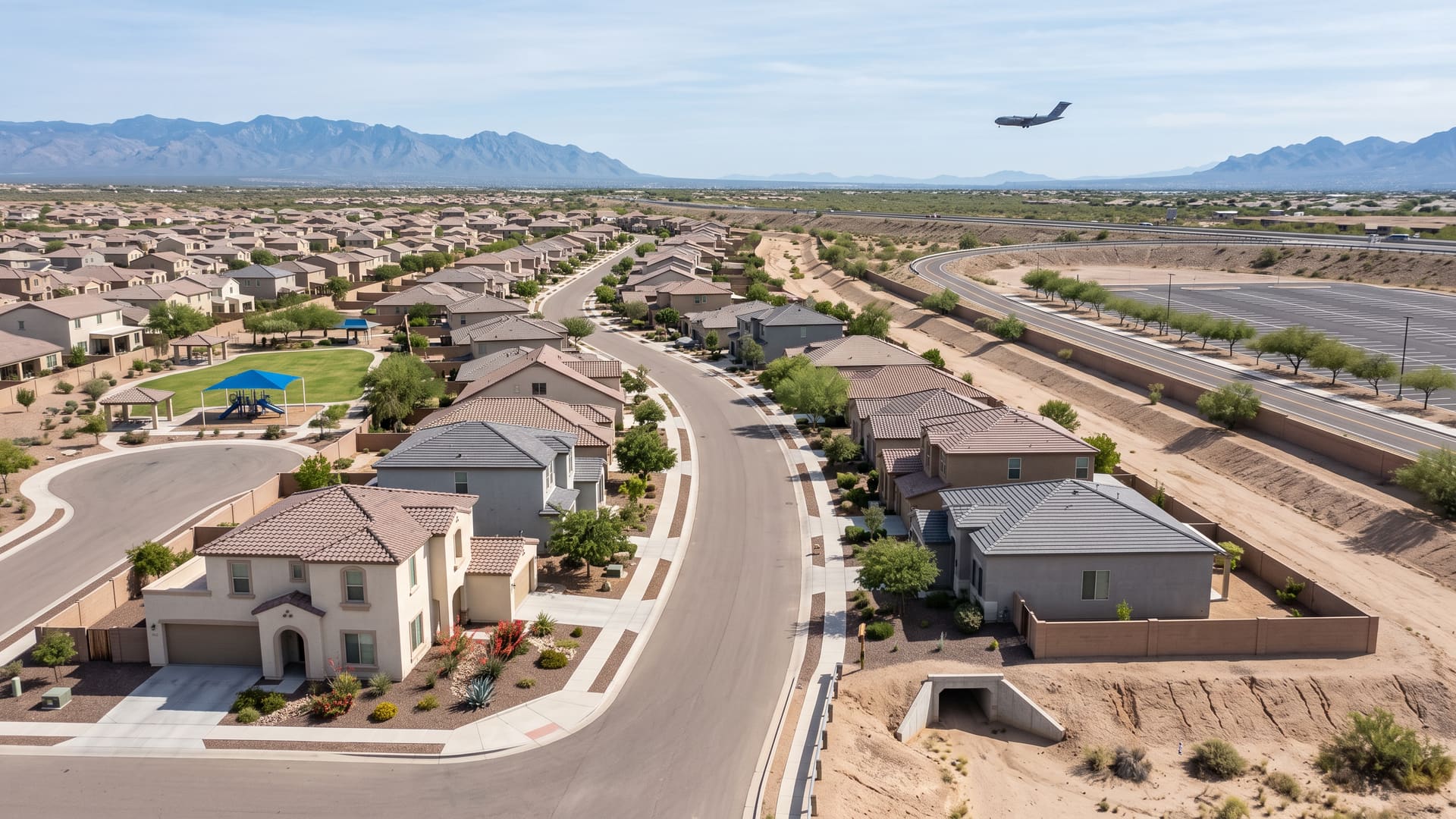
Rancho Valencia Homes for Sale — Tucson, AZ
Rancho Valencia is one subdivision on flat ground in ZIP 85756 on Tucson's far south side, built out in detached stucco houses between 2006 and 2015, with Swan Road down its west side and Interstate 10 across its north-east corner.
Key facts
- Jurisdiction
- Tucson, Arizona — incorporated city, Pima County
- Average sale price
- $311,000
- Price range
- $240K – $400K
- School district
- Sunnyside USD (Craycroft, Lauffer, Desert View)
- Approximate population
- ~2,600
- Approximate number of homes
- ~850 homes
What defines this area
- A homeowners association holding twenty-six acres of common area and a fifteen-acre recreation area
- The Julian Wash Greenway shared-use path half a mile off
- Thomas Jay Regional Park half a mile away
- Interstate 10 at exit 268 on the north-east corner
- Swan Road west, Interstate 10 across the north-east corner
- One recorded subdivision, 641 residential lots on 181 acres
- Two plats, recorded 2005 and 2013, built out by 2015
- R-2 zoning on every one of its 638 parcels, and no other code
- All 65 recent closings detached, and none built before 2006
- Closings built to a median year of 2009
- Living areas 961-3,623 sq ft, median 1,647
- A $300,000 median across the 65, and price tracking floor area
- Rodeo Wash and six unnamed mapped washes crossing it
- Inside the Tucson International Airport avigation easement and disclosure area
- Annexed into the City of Tucson in November 2017, in Ward 5 and in ZIP 85756
About Rancho Valencia
Rancho Valencia is one subdivision on flat ground in ZIP 85756 on Tucson's far south side, built out in detached stucco houses between 2006 and 2015, with Swan Road down its west side and Interstate 10 across its north-east corner. It is also a boundary drawn tightly around that subdivision, and the two are the same thing here in a way they usually are not. Within its 181 acres the county records 649 parcels, and 647 of them carry a Rancho Valencia legal description: 583 numbered lots, 58 more in Rancho Valencia II, four common areas and a public drainageway. Every Rancho Valencia parcel in Pima County is inside this line and none is outside it, which is a rarer thing than it sounds. Most boundaries on this site are a name laid over ground that several subdivisions share; this one is a single subdivision and its own edges. The two parcels that are not part of it are a 14-acre commercial yard in the north-east corner beside the interstate ramp and part of a City-owned drainageway. What sold here over the three years to September 2026 was 65 homes at a $300,000 median, and the record is unusually plain: all 65 were detached houses, not one condominium or townhouse among them, and all 65 were built between 2006 and 2015 to a median year of 2009. What the sold record says about the houses is mostly about their size. Across the three years to September 2026 the 65 closings ran from $234,000 to $455,000 around a $300,000 median and a $311,333 average, on a $300,000 list median. Floor areas ran from 961 square feet to 3,623 to a median of 1,647, and the median closing worked out to $186.56 a square foot inside a range from $123.72 to $251.00. Sort those 65 sales into price bands and the price per square foot falls without a single reversal, from about $233 in the cheapest band to about $134 in the dearest, while median floor area climbs from roughly 1,010 square feet to roughly 3,230. Median year built stays flat across every band. In a tract where everything went up inside one decade to a handful of builder plans, that is what you would expect and it is worth stating: the spread of prices here is very largely a spread of floor area rather than of vintage or of location within the boundary, so the per-square-foot figure is the one to carry between plans. The range printed at the top of this page is drawn around the body of the record rather than its edges: 59 of the 65 closings landed between $240,000 and $400,000, with two below and four above. These are closed sales, not homes for sale. Pace was moderate. The median listing went under contract in 25 days, 38 once relists are counted, and the record closed at 99 cents on the list dollar; 16 of the 65 beat their asking price and 27 cut it first. The days-to-close and days-to-contract fields rest on 64 of the 65 records rather than all of them. The school assignment is the same across the whole boundary, which is not true of most of the pages on this site. Every one of 60 interior sample points returns the same campuses from Pima County's attendance-area polygons, and the county's answer and the MLS data's own point query agree exactly: Craycroft Elementary School, Billy Lane Lauffer Middle School and Desert View High School, all three Sunnyside Unified, with the district's two Gallego fine-arts magnets and STAR Academic High School also returned everywhere because they draw district-wide rather than by address. All three assigned campuses stand outside the line and close to it: Lauffer about four tenths of a mile north-east, Craycroft Elementary about four tenths, and Desert View High about eight tenths west. Assignments are drawn by address and they change, so confirm the assignment for a specific address with the district before relying on it. There is a homeowners association and the public record names it. The City's HOA layer ties this ground to the same book and page as the Block A plat, records the association as Valstate Homeowners' Association covering Rancho Valencia and Valstate together across 1,057 lots, and carries the recorded sequence number for the covenants. All four common areas are held in the name of Valstate HOA Inc on the county's parcel record: a 14.9-acre recreation area, a 6.2-acre drainage area, a 3.3-acre open space and landscape parcel and a 1.7-acre parcel described as recreation and drainage, about 26 acres in all, or one acre in seven of the whole boundary. No dues figure appears in any public record consulted here, so this page does not publish one; ask for the association's current assessment and its resale disclosure package before writing an offer. Note that Valstate is also the name of the 680-lot plat recorded in January 2002 immediately north-west of this boundary, which is why one association covers both. The build-out chronology is in the plat record and it is short. Pima County maps two recorded plats inside the line. Rancho Valencia Block A was recorded on 12 August 2005 at book and page 60017, covering about 152 acres with 183 lots on its face, and Rancho Valencia II followed on 5 December 2013 with 58 lots on about 11 acres. Between them they cover roughly 88 per cent of the boundary; the remainder is street right-of-way, which is what a parcel query at points the plats do not cover returns. Read the recorded lot counts as what each filing recorded rather than as what stands there now: the parcel legal descriptions run to lot 583 against a mapped plat of 183. The builder was KB Home of Tucson, which Inside Tucson Business reported in November 2005 was opening the 276-home Merano subdivision inside what it described as the company's 817-lot, six-subdivision development south of Valencia on Swan Road, after phases it named as Rancho Valencia 1, The Villas and San Lorenzo. Those phase names are marketing names and none of them appears in the county's subdivision layer, so treat the 817 as the plan as reported at the time and the 641 residential lots on the ground as what was built inside this boundary. The City of Tucson's own development-plan layer carries Rancho Valencia II Phases 1 and 2 approved on 30 July 2013 for 58 units, its private grading plan that October, and three older commercial plans on the edges. The zoning is one code and nothing else. All 638 parcels wholly inside the line read R-2 on Pima County's regional parcel layer, with no second zone anywhere among them, and the City's zoning layer records that R-2 polygon as a translation of Pima County CR-4 at every interior point tested. That is the tell on how this place came to be in the city at all. Every plat and every development plan here was recorded under Pima County jurisdiction, and the annexation that brought the ground inside Tucson is Ordinance 11493, effective 10 November 2017, which covers all 60 interior sample points. So the houses were platted, permitted and largely sold in unincorporated Pima County, and the city arrived afterwards. Tucson television station KGUN 9 reported the annexation as more than 600 acres south-east of Swan and Valencia, north of the Los Reales Landfill and on both sides of Craycroft and Interstate 10, and listed what changed for the households inside it: City of Tucson trash collection in place of private haulers, Tucson Police patrol in place of the Pima County Sheriff's Department, Tucson Fire service, and Tucson Water unchanged. That report carries no date on the page, so the date above is the county's recorded effective date and the service changes are attributed to the station. An earlier annexation ordinance, 10096 from January 2005, grazes the boundary without covering any point inside it. The City of Tucson maps a Rancho Valencia neighborhood of its own and it is not the same shape. The City's polygon runs to about 340 acres and crosses Interstate 10 to reach Valencia Road; this boundary is the part south of the freeway, sitting 99.9 per cent inside the City's outline and accounting for 53 per cent of it. The City's layer also records that Rancho Valencia is not a registered neighborhood association, and the registers agree: the City's list of registered associations returns nothing on this ground at all, which is why the association above is a homeowners association under recorded covenants rather than a neighborhood group at City Hall. The boundary lies wholly within one survey section, the 14th of Township 15 South, Range 14 East, and three of its four sides are explained by that. Swan Road on the west runs on the section's west line and the boundary runs with it, sharing a mapped centreline vertex. The south line sits within six metres of the aliquot line a quarter of a mile north of the section's south line. On the western half, the north line sits within fourteen metres of the section's east-west centre line, the half-mile line. The fourth side is the freeway: Interstate 10 cuts across the north-east on a diagonal, taking the corner off the rectangle, and the eastbound off-ramp for exit 268 at Craycroft Road lies inside the boundary. That is why the outline fills only 78 per cent of its own bounding box, which measures about eight tenths of a mile east to west by four and a half tenths north to south. Los Reales Road runs parallel about seventy metres south of the south line rather than on it, and Craycroft Road, which runs on the section's east line, is about two tenths of a mile east of the east side. Two airports sit within about a mile and the disclosure that reaches this ground comes from the civil one, not the military one. Pima County maps the whole boundary inside the Tucson Airport Authority's avigation easement and disclosure area for Tucson International Airport, at all 60 sample points. It maps none of it inside the Davis-Monthan Air Force Base Vicinity, the territory that carries Arizona's military-airport seller disclosure, and none inside the base's noise control districts or its Air Installation Compatible Use Zone, or inside any of the county's three airport environs overlays for height, land use and noise. All of those were re-run over positive controls and every one returned features there, so the absences are real rather than failed queries. The near miss is the interesting part, and it comes with a caveat. The base's own mapped boundary is about nine tenths of a mile north, and yet the statutory vicinity comes no closer than about a tenth of a mile, because Arizona Revised Statutes section 28-8461 draws that territory leg by leg from the runway rather than as a circle around the fence: for Davis-Monthan it reaches five miles north-west and ten miles south-east along the runway line but only a mile and a half to the south-west of it, and this ground sits off that short side. Section 28-8484 is where the military duty lives, and it runs against maps prepared by the state land department rather than against a county layer. What is measured above is Pima County's rendering of the territory, and a tenth of a mile is inside the margin where the two could differ, so treat this as too close to call for a specific address and check the state's map rather than this page. For the civil airport, section 28-8486 works differently: it has the State Real Estate Department keep a map of the territory in the vicinity of each public airport and each public airport record that map with the county recorder, which the statute treats as notice to owners and purchasers, rather than imposing a disclosure at each sale. Whether any particular parcel also carries a recorded avigation easement is a title question, so read the title commitment. Water moves through this place rather than around it. Pima County's wash network maps seven regulated setbacks crossing the boundary, about a mile and six tenths of channel in all. One is named: Rodeo Wash, carrying a 50-foot regulated setback and rated at 1,000 to 2,000 cubic feet per second, with about four tenths of a mile of it inside. The other six are unnamed in that layer, two of them at 50 feet and rated 500 to 1,000 cubic feet per second and four at 25 feet and under 500. The county's bank-protection layer returns nothing inside, so none of them is recorded here as a lined or stabilised channel. The drainage shows up in the ownership record too: one common area is described as drainage and another as recreation and drainage, and the City of Tucson owns a 39-acre parcel legally described as Valstate drainageway and public trail, about 28 acres of which lies inside this boundary. Because a setback is drawn outward from the mapped channel and not from any lot line, whether one reaches a given property is a parcel-level question a survey and a title search answer rather than a neighborhood one. There is no public park inside the line and no mapped public trail, and that is a consequence of the ownership rather than a lack of ground: the 14.9-acre recreation area here is common area held by the association, so the county's parks layer has nothing to show. Outside the line, Thomas Jay Regional Park begins about half a mile away — a Pima County regional park at 6465 South Craycroft Road whose amenities the county lists as lighted ball fields, basketball courts, ramadas, playgrounds, restrooms and the Littletown Community Center, with its own access to The Loop. The Julian Wash Greenway runs about half a mile off with its Valencia trailhead at the same distance; it is one of the named segments of the Chuck Huckelberry Loop, Pima County's system of paved shared-use paths. The Pima Air and Space Museum is about eight tenths of a mile away. Two things nearby belong in any honest description of the location. Davis-Monthan Air Force Base is about nine tenths of a mile north and Tucson International Airport about a mile west, so aircraft overhead are part of the setting; and the City of Tucson's Los Reales Sustainability Campus, which the City describes as the only active landfill it owns and operates, has its 5300 East Los Reales Road address point about two tenths of a mile off the south-east corner. Drive to the boundary at different times of day before deciding. The street names are the one piece of whimsy in an otherwise very regular place. Twenty-seven street names lie wholly inside the boundary and 24 of them are plants: Fairy Duster, Desert Straw, Desert Thorn, Brickellbush, Bittercress, Silverweed, Spring Beauty, Chickweed, Beavertail, Tackweed, Blue Eyes, Green Eyes, Kittentails, Cream Cups, Filaree, Silverpuffs, Catchfly, Salt Cedar, Lady's Thumb, Red Maids, Thimbleberry, Sweetbush, Fishhook, Calypso, Parsnip and Salmonberry among them. The other three are surnames. All 649 county address points inside the line read 85756, the boundary sits entirely in Tucson's Ward 5, and the layout is the standard one of its decade: kerbed streets that curve, short cul-de-sacs, sidewalks, and compact lots averaging about a sixth of an acre. For the drive, Interstate 10 is at the corner at exit 268 and exit 267 at Valencia Road is about eight tenths of a mile north-west; the Tucson International Airport terminal is about 2.9 miles, Pima Community College's Desert Vista Campus about 5.6, the Reid Park Zoo about 5.9, Park Place about 6.6, the University of Arizona about 8.0 and downtown Tucson about 8.2.
Rancho Valencia is a suburban neighborhood in the City of Tucson, on the south side of metro Tucson, Arizona, served by Sunnyside USD (Craycroft, Lauffer, Desert View). Homes trade in the $240K – $400K range, with an average sale price of $311,000 across roughly 850 homes and a population of about 2,600. Kyle Berglund, REALTOR® at Tierra Antigua Realty, represents buyers and sellers here — call (520) 250-8904.
Compare nearby Tucson neighborhoods
- La Estancia — New Build, average $385,000
- Elvira — Affordable, average $257,000
- Vail — Suburban, average $421,000
- Sahuarita — Affordable, average $360,000
- Rancho Sahuarita — New Build, average $370,000
- Madera Highlands — Affordable, average $400,000
- Green Valley — 55+, average $315,000
- Tanque Verde — Suburban, average $560,000
Frequently asked questions
What city is Rancho Valencia in?
Rancho Valencia is in the City of Tucson, Arizona. Jurisdiction: Tucson, Arizona — incorporated city, Pima County.
What is the average home price in Rancho Valencia, Tucson?
The average sale price in Rancho Valencia is approximately $311,000, with homes generally ranging from $240K – $400K. These are rounded, long-run estimates aggregated from MLSSAZ closed sales through the LiveBy data connection, over this neighborhood's own boundary, for general orientation — not a current-month figure. Averages are means and can be skewed by a small number of high-value sales, so individual home values vary materially.
What school district serves Rancho Valencia?
Rancho Valencia is served by Sunnyside USD (Craycroft, Lauffer, Desert View). Confirm exact school assignments by specific address, as boundaries can change.
Is Rancho Valencia a good place to live?
Rancho Valencia is a suburban neighborhood in the City of Tucson, on the south side of metro Tucson, Arizona, known for a homeowners association holding twenty-six acres of common area and a fifteen-acre recreation area, the Julian Wash Greenway shared-use path half a mile off, Thomas Jay Regional Park half a mile away, Interstate 10 at exit 268 on the north-east corner. Rancho Valencia is one subdivision on flat ground in ZIP 85756 on Tucson's far south side, built out in detached stucco houses between 2006 and 2015, with Swan Road down its west side and Interstate 10 across its north-east corner. It has an approximate population of ~2,600 across roughly ~850 homes.
What kind of homes are for sale in Rancho Valencia?
Rancho Valencia is a suburban submarket where homes generally trade between $240K – $400K, with an average sale price of $311,000.
Who can help me buy or sell a home in Rancho Valencia?
Kyle Berglund, a licensed Arizona REALTOR® (License #SA668710000) at Tierra Antigua Realty, specializes in Rancho Valencia and the greater Tucson area. Call (520) 250-8904 or email contact@kyleberglund.com for a free consultation.