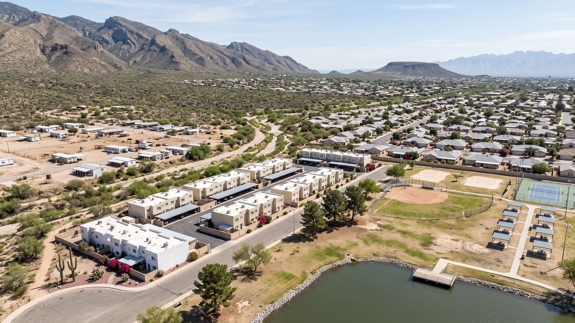
Westside Development Homes for Sale — Tucson, AZ
Westside Development is a 1,559-acre district on Tucson's west side, running from the foot of the Tucson Mountains east to South La Cholla Boulevard. What sits inside it is the first thing to know.
Key facts
- Jurisdiction
- Tucson, Arizona — incorporated city, Pima County
- Average sale price
- $294,000
- Price range
- $200K – $400K
- School district
- TUSD (Oyama or Tolson Elementary, Valencia or Mansfeld Middle, Cholla High)
- Approximate population
- ~4,900
- Approximate number of homes
- ~2,000 homes
What defines this area
- John F. Kennedy Park inside the boundary at 162.7 acres
- The ten-acre Kennedy Lake in the Community Fishing Program
- Tucson Mountain Park reaching into the western end
- Oyama Elementary School standing inside the boundary
- Eight named desert trails lying wholly inside the boundary
- The Richard Elías-Mission Library, renovated and reopened in 2026
- Starr Pass Boulevard north, La Cholla Boulevard east, Ajo Way south
- Recent closings built 1931-2024, median year 1981
- Living areas 800-2,510 sq ft, median 1,309
- Twenty-nine townhouses among 92 recent closings
- Kennedy Park Townhouses and Park West Townhouses
- Fourteen recorded plats holding 1,255 lots, from 1947 to 2010
- Manufactured homes on unplatted parcels across the western side
- Enchanted Hills Wash crossing in soft earthen banks
- Wholly inside the City of Tucson, entirely in Ward 1
- One ZIP code across all 1,509 county address points
About Westside Development
Westside Development is a 1,559-acre district on Tucson's west side, running from the foot of the Tucson Mountains east to South La Cholla Boulevard. What sits inside it is the first thing to know. John F. Kennedy Park lies wholly within the boundary, and Pima County's Tucson Mountain Park reaches into the western end, so the last streets on that side finish at open desert rather than at another subdivision. Between the two, the housing is mostly 1970s and 1980s, about a third of it attached, and the 92 sales recorded inside the boundary over the last three years closed at a $295,000 median. The shape is not a rectangle, and that is worth knowing before reading a map of it. A band two miles wide and half a mile deep runs east to west across the middle; a lobe rises a further mile north from its eastern end to West Starr Pass Boulevard; a second lobe drops half a mile south from its middle to West Ajo Way and reaches half a mile further east, where South Mission Road closes it. Its bounding box is less than half full, so a rectangle drawn around this place takes in as much ground outside it as in. The name is the next thing, because it is not on a street sign here. The City of Tucson registers an active neighborhood association over this ground called Westside, in Ward 1, and that outline is what this boundary is: 1,556 acres against the boundary's 1,559, and the two lines nowhere more than about a hundred and ten feet apart. Every one of the 41 interior points tested returns Westside and no other association; four others — Santa Cruz Southwest, Menlo Park, A Mountain and Enchanted Hills — clip the edges and cover no interior ground at all. No street inside the boundary carries the name, and no recorded plat does either. LiveBy's label for the area is Westside Development and the City's register says Westside. Where the edges are not arterials they are survey lines, and they are close ones. The western edge lands on the section line that divides Township 14 South, Range 13 East at its western end, to within the resolution of the two records. The northern edge of the western band follows the next section line east of it; the southern edge of that band follows the half-section line through the middle of two sections; the north, east and south edges of the lobes sit within about thirty-five feet of a section line each. Eleven complete sections intersect the boundary. That is also why the west side has no road on it: the ground out there is open desert at the foot of the mountains, and the survey grid is the only line to draw. One thing to know if you are comparing this page with its neighbor. The boundary shares twenty-six of its sixty-six corner points, coordinate for coordinate, with the boundary behind this site's Starr Pass page — the two tile against each other along their whole common frontier rather than overlapping. But the plat recorded as Starr Pass Shadows, 139 lots filed in August 1995, lies wholly inside this boundary and not inside that one. Every other Starr Pass-named plat in the county's record lies outside this line. Names and boundaries are drawn by different offices and they do not have to agree. Public parkland is a large share of the interior, which is the other half of why an arterial reading of this place is wrong. Of 41 points tested evenly across the boundary, eleven fall inside a park — six in Tucson Mountain Park and five in John F. Kennedy Park. That is a sample rather than a survey, so read it as a lot of parkland and not as a percentage of the acreage. Tucson Mountain Park is the Pima County park established in April 1929 that the county describes as roughly 20,000 acres with about 62 miles of shared-use trails, and the boundary's western band runs into it rather than stopping at it. Kennedy Park lies wholly inside. The City of Tucson lists it as a Metro Park of 162.7 acres in Ward 1 at 3700 South Mission Road. Its published facility list runs to a baseball field, basketball court, batting cages, benches, bicycle racks, a dog park, a drinking fountain, a fire ring, grills, grandstand seating, horseshoe pits, a little league field, a multi-purpose field, picnic tables, two playgrounds — one of them shaded — public art, a ramada, restrooms, soccer and softball fields, tennis courts and volleyball courts. Kennedy Lake sits inside the park at 3600 South La Cholla Boulevard: ten acres, twelve feet at its deepest, which the City manages jointly with the Arizona Game and Fish Department under the Community Fishing Program. Gas-powered motorboats are not allowed, boats are limited to fourteen feet and canoes and kayaks to seventeen, and anyone fishing follows Arizona Game and Fish regulations. Kennedy Pool is there too — a 25-yard recreational pool with one-metre and three-metre boards and a wading pool — and it is worth checking before you plan around it, because the City currently lists it as closed until summer 2027. Eight named trails the county records as open lie wholly inside the boundary: Frick, Tecolote, Fire 7, El Grupo Loop, High Noon, Greasewood Express and Enchanted Peak, all natural-surface singletrack marked for walkers and bicycles, plus two hard-surfaced segments of Greasewood Road. The 36th Street Trail crosses the boundary without being contained by it. What sells here is 1970s and 1980s housing with a long tail on either side. All 92 closings recorded inside this boundary over the last three years were built between 1931 and 2024, to a median year of 1981. They ran $41,000 to $625,000 against a $295,000 median and a $293,685 average, on a $307,450 list median, and took a median 17 days on market, the same 17 counting relists, at a sale-to-list ratio of 0.99. Nineteen of the 92 closed above asking and 24 took a price reduction first. Living areas ran 800 to 2,510 square feet with a 1,309-square-foot median, and the median price per square foot was $214.79. Read the price band on this page as what it says: 76 of the 92 closed between $200,000 and $400,000, but nine closed below that and seven above it, the top one at $625,000. A third of the market is attached. Twenty-nine of the 92 sales were townhouses, 62 were detached houses, and one was a condominium. The two move differently in both directions. The townhouses closed at a $232,000 median on 1,168 square feet, at $197.85 a square foot, in a median 15 days; the detached houses closed at $329,500 on 1,480 square feet, at $223.14 a square foot, in a median 17. The townhouses were built between 1974 and 2004, the detached houses between 1931 and 2024 — so the attached stock here is one narrow generation and the detached stock is nearly a century of it. Note that the $41,000 close is a townhouse and is what produces the $35 per square foot floor in the record; it is one sale and says nothing about any other. The attached ground is two tracts and not a scatter. Every one of the 305 parcels the county files under its attached-unit code is zoned R-2, and 120 of them carry a Kennedy Park Townhouses legal description while 185 carry a Park West Townhouses one. Another 899 parcels carry the detached single-family code. Zoning here is five districts and nothing else: 925 parcels R-1, 321 MH-1, 313 R-2, 36 SR and 24 RX-1, out of 1,619 wholly inside the boundary, every one of them City of Tucson. MH-1 is the Mobile Home Zone in the City's Unified Development Code, which the City describes as providing for low to medium density residential development primarily in mobile homes, and 321 parcels is a fifth of the ground — most of it out west, on land no plat covers. Two things follow from that. Manufactured housing on its own parcel is a real part of what is here, and financing it is a different conversation from financing a stick-built house on the same street. And zoning is about to mean something different from what it meant when this ground was built: Tucson's middle housing amendment was adopted by Mayor and Council on 16 December 2025 and took effect on 1 January 2026, permitting middle housing including townhomes across essentially every residential zone in the city, R-1 included, citywide except in rural residential areas. The plat record is fourteen filings, and they are legible as waves. Casas Oestes, 22 lots, came first in November 1947, then Paradise Mountain Estates with 64 lots in February 1961. The bulk arrived in one decade: Tucson Park West No. 2 in two filings of 84 and 144 lots in 1972 and 1973, Kennedy Park Townhouses with 125 in October 1972, Park West Townhouses with 183 in September 1973, and Paseo Vista with 234 in September 1974. Tucson Park West No. 4 added 101 in 1980 and Paseo Vista No. 2 another 14 in 1981. Then a long gap and four smaller filings: Starr Pass Shadows with 139 in 1995, Kennedy Park Hills with 100 in 1996, Hermosa Heights with nine in 1998, San Marcos Terrace with 33 in 2005, and a three-lot filing on West Mockingbird Lane in April 2010. Those fourteen plats account for 1,255 lots against 1,619 parcels, and the difference is the unplatted metes-and-bounds ground on the western side. Homeowners associations exist here but they do not cover the boundary. Eight of them own common-area parcels inside it: Kennedy Park Hills, San Marcos Terrace, Tucson Park West No. 3, Tucson Park West No. 4, Park West Townhouses, Kennedy Park Townhouse, Starr Pass Shadows and Mission Harbor. The City of Tucson owns the other 25 common-area parcels. No dues figure is published on this page because the parcel record carries none, and owning no common ground is not the same as having no association — an association can govern a plat under recorded covenants without holding a parcel, so that question belongs to the title commitment for a specific address rather than to a map. One thing to look into before an offer on the southern end. The Tucson Airport Authority's avigation and disclosure area reaches into this boundary, but only into the southern lobe: seven of the 41 interior points tested fall inside it and all seven are at the south end, with none of the northern two-thirds touched. Tucson International is not a military airport, so nothing about that overlay carries the Arizona statutory seller notice that the territory around Davis-Monthan Air Force Base does — and that territory returns nothing at all here, as do the county's Air Installations Compatible Use Zone layers, its approach-departure corridors and all three of its airport environs overlays. Confirm it for a specific address rather than for the block. The county's hydrology layer returns one named reach inside the boundary, Enchanted Hills Wash, recorded with natural banks and a flow class above 2,000 cubic feet per second; no regulated wash setback is mapped anywhere inside. School assignment is Tucson Unified throughout and it splits once, along a line near the top of the northern lobe. Thirty-four of the 41 interior points return Oyama Elementary, which stands inside the boundary at 2700 South La Cholla Boulevard, with Valencia Middle School and Cholla High School. The seven points north of that line return Tolson Elementary and Mansfeld Middle Magnet School, still with Cholla High. One thing to be precise about: the two records disagree about Cholla's grade span, the school record returned with the assignment giving it as 8-12 and the county's attendance layer as 9-12. A grade span is what a campus enrolls, not what an address is assigned to. Assignments are drawn by address and they change, so confirm the assignment for a specific address with the district before relying on it. For orientation, all 1,509 official county address points inside the boundary read ZIP 85713, and every part of it is in Ward 1. The Richard Elías-Mission Library stands inside the southern lobe at 3770 South Mission Road; Pima County Public Library closed it for a major renovation on 11 March 2024, describes it now as newly renovated and expanded, and held its grand reopening on 13 June 2026. A United States Border Patrol station sits on West Ajo Way inside the same lobe. Measured from the boundary's edge, the nearest Interstate 19 ramp is a mile away and the nearest Interstate 10 ramp a mile and a fifth; Pima Community College's West Campus is just under two miles, St. Mary's Hospital a mile and a half, the Tucson Convention Center and downtown two and a quarter miles, the University of Arizona about four, Banner University Medical Center South four and a third, and the Tucson International Airport terminal about five and a third.
Westside Development is a suburban neighborhood in the City of Tucson, on the west side of metro Tucson, Arizona, served by TUSD (Oyama or Tolson Elementary, Valencia or Mansfeld Middle, Cholla High). Homes trade in the $200K – $400K range, with an average sale price of $294,000 across roughly 2,000 homes and a population of about 4,900. Kyle Berglund, REALTOR® at Tierra Antigua Realty, represents buyers and sellers here — call (520) 250-8904.
Compare nearby Tucson neighborhoods
- Vail — Suburban, average $421,000
- Tanque Verde — Suburban, average $560,000
- Rancho Vistoso — Suburban, average $505,000
- Catalina — Suburban, average $475,000
- Starr Pass — Luxury, average $498,000
- Tucson Estates — 55+, average $429,000
- Indian Ridge Estates — Suburban, average $695,000
- Harold Bell Wright Estates — Suburban, average $498,000
Frequently asked questions
What city is Westside Development in?
Westside Development is in the City of Tucson, Arizona. Jurisdiction: Tucson, Arizona — incorporated city, Pima County.
What is the average home price in Westside Development, Tucson?
The average sale price in Westside Development is approximately $294,000, with homes generally ranging from $200K – $400K. These are rounded, long-run estimates aggregated from MLSSAZ closed sales through the LiveBy data connection, over this neighborhood's own boundary, for general orientation — not a current-month figure. Averages are means and can be skewed by a small number of high-value sales, so individual home values vary materially.
What school district serves Westside Development?
Westside Development is served by TUSD (Oyama or Tolson Elementary, Valencia or Mansfeld Middle, Cholla High). Confirm exact school assignments by specific address, as boundaries can change.
Is Westside Development a good place to live?
Westside Development is a suburban neighborhood in the City of Tucson, on the west side of metro Tucson, Arizona, known for John F. Kennedy Park inside the boundary at 162.7 acres, the ten-acre Kennedy Lake in the Community Fishing Program, Tucson Mountain Park reaching into the western end, Oyama Elementary School standing inside the boundary. Westside Development is a 1,559-acre district on Tucson's west side, running from the foot of the Tucson Mountains east to South La Cholla Boulevard. It has an approximate population of ~4,900 across roughly ~2,000 homes.
What kind of homes are for sale in Westside Development?
Westside Development is a suburban submarket where homes generally trade between $200K – $400K, with an average sale price of $294,000.
Who can help me buy or sell a home in Westside Development?
Kyle Berglund, a licensed Arizona REALTOR® (License #SA668710000) at Tierra Antigua Realty, specializes in Westside Development and the greater Tucson area. Call (520) 250-8904 or email contact@kyleberglund.com for a free consultation.