Myers Homes for Sale — Tucson, AZ
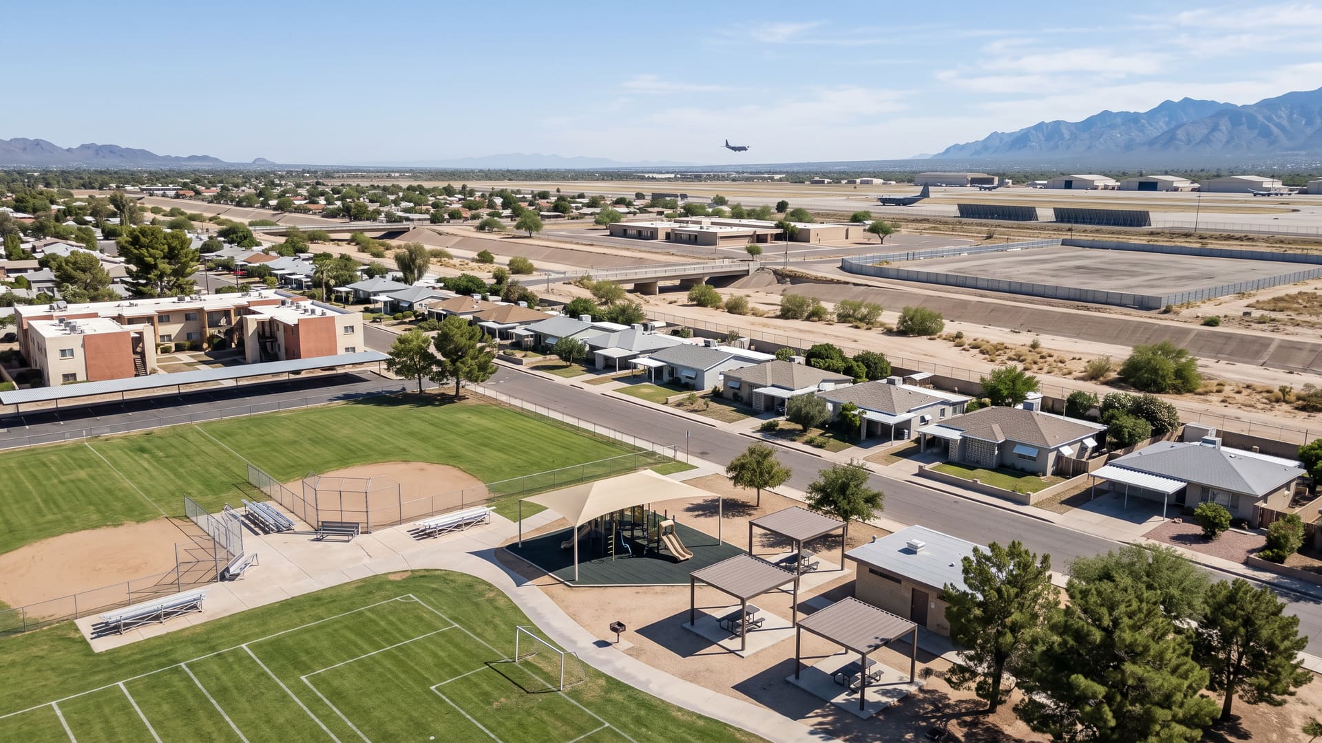
Myers is the square mile between East 22nd Street, South Swan Road, South Craycroft Road and East Golf Links Road, on dead-flat ground in ZIP 85711 on Tucson's east side. Two things set it apart from the sections around it.
Key facts
- Jurisdiction
- Tucson, Arizona — incorporated city, Pima County
- Average sale price
- $255,000
- Price range
- $200K – $350K
- School district
- TUSD (Myers-Ganoung Elementary, Roberts-Naylor K-8, Rincon High)
- Approximate population
- ~5,000
- Approximate number of homes
- ~2,300 homes
What defines this area
- Freedom Park and the Todd M. Harris Sports Complex, both inside the line
- A 1958-1960 house tract of 753 platted lots on a plain numbered grid
- Davis-Monthan Air Force Base across Golf Links Road along the south side
- Myers-Ganoung Elementary School inside the boundary on East Andrew Street
- East 22nd Street north, South Swan Road west, South Craycroft Road east
- Section 23 of Township 14 South, Range 14 East, less the Golf Links wedge
- 1,102 county parcels on 565 acres, 935 of them detached house lots
- Detached lots running about a sixth of an acre
- Living areas 920-2,362 sq ft, median 1,238
- A $255,000 median across 64 closings, every one of them detached
- Build years 1958-1968, median 1959
- 12 days to contract at the median, 18 of 64 over asking
- Freedom Pool and the Freedom Park Center on the same ground
- R-1, R-2 and R-3 tracts side by side, C-2 along the arterials
- No homeowners association recorded over any part of it
- Inside the Davis-Monthan Air Force Base vicinity disclosure territory
- Ward 4, ZIP 85711, and 5.3 miles of mapped wash inside the line
About Myers
Myers is the square mile between East 22nd Street, South Swan Road, South Craycroft Road and East Golf Links Road, on dead-flat ground in ZIP 85711 on Tucson's east side. Two things set it apart from the sections around it. Davis-Monthan Air Force Base begins on the far side of Golf Links Road and runs the whole length of the southern edge — close enough that the two mapped outlines meet in the roadway, and close enough that the Arizona military-airport disclosure described below reaches every address inside the line. And two City of Tucson parks sit wholly inside the boundary rather than beside it, about 88 acres between them: Freedom Park, which carries a pool and a recreation centre on the same ground, and the Todd M. Harris Sports Complex. The third thing is the price, and the reason you can trust it. Sixty-four homes changed hands inside the line over the three years to September 2026, and every one of them was a detached single-family house — no condominium and no townhouse in the record at all. They were built between 1958 and 1968 to a median year of 1959, they ran from 920 to 2,362 square feet to a median of 1,238, and they closed between $140,000 and $400,000 around a median of $255,000. The average was $255,219, which sits $219 from the median, and 58 of the 64 closed between $200,000 and $350,000. A median usually has to be read alongside a caveat about what it is hiding. This one does not. The boundary and the name are the same thing here, which is rarer than it sounds. The City of Tucson has a registered neighborhood association called Myers, active since 1 February 1998, and the City's own record states its limits in words as 22nd Street, Craycroft, Swan and Golf Links — the four streets above. Measured against each other, the association's outline covers 564.0 acres and this boundary covers 565.4, with 99.4 per cent of this line falling inside the association and 99.8 per cent of the association falling inside this line, and all 69 interior sample points returning Myers and nothing else. The ground is also a survey section almost exactly: Section 23 of Township 14 South, Range 14 East, less the wedge that Golf Links Road cuts off the southern side. All four edges check against Pima County's street centreline layer — 22nd Street to within about a metre of the north line, Craycroft to within five of the east, Swan to within twenty of the west. Golf Links is the one that bends: it runs level along the south for roughly two thirds of a mile from Swan, then turns south-east and drops about a fifth of a mile by the time it reaches Craycroft, and the boundary follows that turn. Here is the closed-sale record in full. Over the three years to September 2026 there were 64 closings, and grouping them by property sub-type returns 64 single-family residences, zero condominiums and zero townhouses. Close prices ran $140,000 to $400,000 with a $255,000 median and a $255,219 average, against a $260,000 list median and a $261,250 original-list median. Build years ran 1958 to 1968 with a 1959 median and a 1959.64 average — an eleven-year span, and the tightest this site has published for any boundary of this size. Floor areas ran 920 to 2,362 square feet with a 1,238 median, and price per square foot ran $121.78 to $290.76 with a $203.02 median. Sorted into price bands, the record puts 2 closings under $150,000, 3 from $150,000 to $200,000, 5 from $200,000 to $225,000, 14 from $225,000 to $250,000, 22 from $250,000 to $275,000, 10 from $275,000 to $300,000, 7 from $300,000 to $350,000, none from $350,000 to $400,000 and 1 above $400,000. So the range printed at the top of this page is drawn around the body of that record rather than around its extremes: 58 of the 64 landed between $200,000 and $350,000, five below and one above. Price per square foot does not climb steadily across those bands — it runs $152, $137, $218, $234, $198, $210, $211 and then $169 at the top — so no reading about bigger houses being cheaper by the foot is drawn from it here. These are closed sales, not homes currently for sale. Things moved quickly. The median listing went under contract 12 days after it came to market and 34 days after listing by the measure that counts relists, and it took 44 days from contract to close. The record closed at 98 cents on the list dollar, 18 of the 64 beat their asking price, and 19 took a price reduction first. Days on market rest on 63 of the 64 records rather than all of them. There is no homeowners association recorded anywhere inside this boundary. Neither the City of Tucson's homeowners-association layer nor Pima County's returns a single feature over any part of it, and no dues figure exists to publish. The association called Myers is a voluntary neighborhood association registered with the City, which is a different thing from an HOA: it has bylaws, adopted 3 March 1998, and an annual meeting each November, and it has no assessment power and no covenant authority over anyone's title. The one exception to check is the Thunderbird Palms Villas condominium, which is a condominium regime by its nature and will have its own governing documents; ask for those and the resale disclosure package before writing an offer on a unit there. The build-out chronology comes off the plat record and it is compressed into about two and a half years. Ten recorded plats lie wholly inside the line. The oldest is Ferry Addition, 187 lots recorded on 16 November 1948, with a single-lot Alamo Acres filing in March 1951. Then nothing for seven years, and then almost everything at once: Craycroft Terrace with 138 lots on 6 March 1958, Mayfair Terrace with 240 lots on 7 August 1958 and 155 more on 16 October 1958, Mayfair Terrace No. 2 with 214 lots on 26 February 1959, and a six-lot Mayfair Terrace filing in May 1960. That is 753 lots recorded in twenty-seven months, which is why the sold record's build years cluster so hard on 1958 and 1959. Craycroft Gardens followed in October 1963 and the Thunderbird Palms Villas condominium in November 1979. The tenth is new: Swan & 29th Street, nine lots on 27.8 acres, recorded on 22 December 2025, the only ground here platted in the last forty-five years. The county still carries all nine of those lots under its vacant-land use code, and the City's zoning layer shows them as the only place inside the boundary where the current zoning differs from the original — rezoned from R-1 to a planned area development. The ground came into the City of Tucson in three stages rather than one. Ordinance 1895, effective 26 April 1959, covers 53 of the 69 interior sample points and is the annexation that brought in the housing — the same ordinance that took in Miramonte Terrace four miles east. Ordinance 4001, effective 19 December 1978, covers ten points in the south-west corner, and Ordinance 6533, effective 6 November 1986, covers six in the south-centre; between them those two are most of the park ground along the southern edge, so the parks came into the city two and three decades after the houses. A fourth ordinance from January 1956 touches the edge without covering any point inside. Note that the first five house plats were all recorded under City of Tucson jurisdiction between March 1958 and February 1959, which is up to thirteen months before the April 1959 ordinance. What the county record holds is 1,102 parcels wholly inside the line, every one of them under City of Tucson jurisdiction with no unincorporated pocket anywhere. Of those, 935 carry a single-family use code on 168 acres, 31 carry a multi-family code on 46 acres, 30 are commercial on 12 acres, 12 are vacant on 29 acres and 17 are public or exempt land on 122 acres. The county's development-plan record names what accounts for most of the difference between those 935 detached lots and the 2,276 dwelling units the census counts here: Freedom Park Apartments, a 336-unit development plan approved under City of Tucson jurisdiction on 9 September 1986. The same record carries a Walgreens at 22nd and Craycroft from October 2003 and a QuikTrip from May 2009, which is the commercial frontage. Detached lots run a median of 0.168 of an acre, from 0.134 to 0.340 — a sixth of an acre rather than the fifth or quarter that 1950s Tucson tracts often show. Add every parcel together and they come to 438 acres against the boundary's 565, so roughly 127 acres of this square mile is street right-of-way. Zoning runs to seven codes, and they map onto the plats almost one for one: Mayfair Terrace is R-2 across 396 of its 413 parcels, Mayfair Terrace No. 2 is R-1 across 222 of 233, Ferry Addition is R-1 across 187 of 207, and Craycroft Terrace is R-3 across 144 of 149, with 85 C-2 parcels, 10 C-1 and 7 O-3 along the four arterial frontages. Four tracts of much the same houses sitting in three different residential districts is worth knowing before anyone plans an addition or a second unit here — the entitlement varies block to block in a way the streetscape does not. Parks are the reason a square mile holds only 935 house lots. Two City of Tucson parks sit wholly inside the boundary and account for about 88 acres of it, or roughly one acre in six. Freedom Park, 39.1 acres at 5000 East 29th Street, is open sunrise to 10:30 p.m. and carries a baseball field, a Little League field, a softball field, a multi-purpose field, basketball and racquetball courts, horseshoe pits, fitness stations, a playground, a seasonal splash pad running daily from 1 April to 31 October, ramadas, picnic tables, grills, restrooms, benches, bicycle racks, a drinking fountain, a Little Free Library and a walking path — and on the same ground, the Freedom Park Center recreation facility and Freedom Pool. The Todd M. Harris Sports Complex, 49 acres at 2400 South Craycroft Road, is open 6 a.m. to 10:30 p.m. with a soccer field, a softball field, a shaded playground, ramadas, picnic tables, grills, restrooms, benches, bicycle racks and a drinking fountain. The Aviation Greenway shared-use path runs inside the line along the southern edge for most of its width. Water crosses this place in quantity, which is the other reason the lot count is what it is. Pima County's wash network records about 5.3 miles of regulated channel inside 565 acres — more per acre than anywhere else this site has measured. The largest is the Tucson Diversion Channel, an engineered flood-control channel rated at 2,000 to 5,000 cubic feet per second and carrying a 75-foot regulated setback, with about 1.1 miles of it inside the line. Naylor Wash accounts for about 1.3 miles at a 50-foot setback, the 29th Street Wash about 0.8 of a mile at 25 feet, Swan Park Wash about a third of a mile and Arcadia Wash a short length at the same setback, with roughly 1.6 miles more unnamed in that layer. A setback is measured outward from the mapped channel rather than from any lot line, so whether one reaches a given property is a parcel-level question for a survey and a title search rather than a neighborhood one. The school assignment is the same across the whole boundary and one of the three campuses is inside it. All 69 interior sample points return the same three from Pima County's attendance-area polygons, and a LiveBy point query at the centre of the boundary returns the identical three as assigned: Myers-Ganoung Elementary School for the elementary grades, Roberts-Naylor K-8 for the middle grades and Rincon High School, all three Tucson Unified. Myers-Ganoung stands inside the line at 5000 East Andrew Street; Roberts-Naylor is about four tenths of a mile west of the boundary at 1701 South Columbus Boulevard and Rincon High about one and four tenths of a mile north at 421 North Arcadia Avenue. A boundary-wide query returns two more campuses than a point query does, because any attendance area that so much as clips the line comes back; the three above are what the county's polygons and the point query agree on. Assignments are drawn by address and they change, so confirm the assignment for a specific address with the district before relying on it. The military airfield next door carries a disclosure duty, and it reaches every address inside this line. Davis-Monthan Air Force Base's mapped outline comes within about fourteen metres of this boundary — the two polygons meet in the Golf Links Road right-of-way — and Pima County maps all 69 interior sample points inside the Davis-Monthan Air Force Base Vicinity, the territory Arizona Revised Statutes section 28-8461 defines and section 28-8484 attaches a seller disclosure to. That definition is drawn leg by leg from the runway rather than as a circle, and for Davis-Monthan it reaches five miles north-west along the runway line, ten miles south-east, six and a half miles north-east and a mile and a half south-west; this ground sits off the long north-east leg. Noise is mapped over part of it as well. Nine of the 69 points, forming a wedge across the south-west corner that reaches about two thirds of the way north along Swan Road and fades out a third of the way east, fall inside Davis-Monthan's 65-to-70 LDN contour: the county maps them in the Airport Environs Noise Overlay Zone, in the Airport Environs Land Use Overlay Zone as Noise Control Zone A, and in the base's own Noise Control District A, three layers agreeing on the same nine points. Seventeen of the 69 also fall inside Airport Environs Height Overlay Zone 3, on the base's inner horizontal surface, where mapped height limits read 120 to 140 feet at twelve of them and 100 to 120 feet at five. None of the boundary falls inside the base's Air Installation Compatible Use Zone, none inside its mapped approach and departure corridors, and none inside the Tucson Airport Authority's avigation easement and disclosure area. The statutory disclosure runs against a map prepared by the state land department rather than against a county layer, so treat all of this as Pima County's rendering and confirm a specific address against the state's map and the seller's own disclosure. Aircraft overhead are part of the setting here in any case. The street grid is as plain as the housing. The county addresses 1,256 official address points inside the line, every one of them in ZIP 85711, across twenty-six street names — the numbered streets from 22nd through 32nd carry more than half of them, with 29th Street the busiest at 129 and 25th Street next at 111, and the named avenues are Andrew, Rosemont, Woodland, Beverly, Cloverland, Magnolia, Farwell, Stern, Arcadia, Ferry, Frances, Mountain View, Santa Rosa and Avenida Carolina. The whole boundary sits in Tucson's Ward 4. Corbett, the next square mile east across Craycroft Road, has its own page here and is bounded the same way — 22nd Street, Golf Links Road, and arterials on both sides — so the two read usefully together. For the drive, the Davis-Monthan main gate at Craycroft is about a mile and a half, Park Place about one and three quarters, El Con Center about two and a quarter, the Reid Park Zoo about two and a third, Tucson Medical Center about two and nine tenths, Pima Community College's East Campus about four and an eighth, the University of Arizona about four and a half, downtown Tucson about five and a half and Tucson International Airport about six and a half.
Myers is an affordable neighborhood in the City of Tucson, on the central side of metro Tucson, Arizona, served by TUSD (Myers-Ganoung Elementary, Roberts-Naylor K-8, Rincon High). Homes trade in the $200K – $350K range, with an average sale price of $255,000 across roughly 2,300 homes and a population of about 5,000. Kyle Berglund, REALTOR® at Tierra Antigua Realty, represents buyers and sellers here — call (520) 250-8904.
Compare nearby Tucson neighborhoods
- Corbett — Affordable, average $278,000
- Rita Ranch — Affordable, average $370,000
- Downtown Tucson — Urban, average $400,000
- Sahuarita — Affordable, average $360,000
- Madera Highlands — Affordable, average $400,000
- Midtown Tucson — Urban, average $350,000
- Sam Hughes — Urban, average $650,000
- Barrio Viejo — Urban, average $590,000
Frequently asked questions
What city is Myers in?
Myers is in the City of Tucson, Arizona. Jurisdiction: Tucson, Arizona — incorporated city, Pima County.
What is the average home price in Myers, Tucson?
The average sale price in Myers is approximately $255,000, with homes generally ranging from $200K – $350K. These are rounded, long-run estimates aggregated from MLSSAZ closed sales through the LiveBy data connection, over this neighborhood's own boundary, for general orientation — not a current-month figure. Averages are means and can be skewed by a small number of high-value sales, so individual home values vary materially.
What school district serves Myers?
Myers is served by TUSD (Myers-Ganoung Elementary, Roberts-Naylor K-8, Rincon High). Confirm exact school assignments by specific address, as boundaries can change.
Is Myers a good place to live?
Myers is an affordable neighborhood in the City of Tucson, on the central side of metro Tucson, Arizona, known for Freedom Park and the Todd M. Harris Sports Complex, both inside the line, a 1958-1960 house tract of 753 platted lots on a plain numbered grid, Davis-Monthan Air Force Base across Golf Links Road along the south side, Myers-Ganoung Elementary School inside the boundary on East Andrew Street. Myers is the square mile between East 22nd Street, South Swan Road, South Craycroft Road and East Golf Links Road, on dead-flat ground in ZIP 85711 on Tucson's east side. It has an approximate population of ~5,000 across roughly ~2,300 homes.
What kind of homes are for sale in Myers?
Myers is an affordable submarket where homes generally trade between $200K – $350K, with an average sale price of $255,000.
Who can help me buy or sell a home in Myers?
Kyle Berglund, a licensed Arizona REALTOR® (License #SA668710000) at Tierra Antigua Realty, specializes in Myers and the greater Tucson area. Call (520) 250-8904 or email contact@kyleberglund.com for a free consultation.