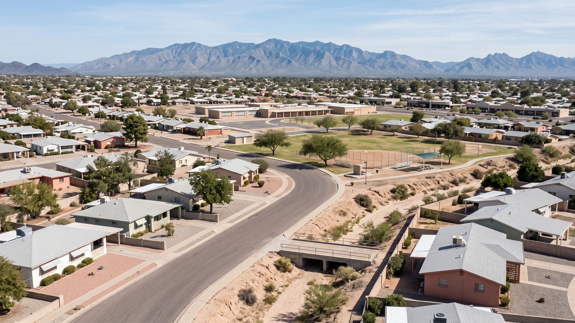
Rosemont West Homes for Sale — Tucson, AZ
If you are pricing a house in Rosemont West, the usual two levers do not work here.
Key facts
- Jurisdiction
- Tucson, Arizona — incorporated city, Pima County
- Average sale price
- $326,000
- Price range
- $250K – $450K
- School district
- TUSD (Bonillas, Alice Vail, Rincon High)
- Approximate population
- ~1,600
- Approximate number of homes
- ~710 homes
What defines this area
- All 55 closings detached, with no attached sale on the record
- A $321,900 median across 55 closings in three years
- Six plats recorded between August 1949 and December 1958
- No plat recorded inside the line in the sixty-eight years since
- R-1 zoning on 728 of the 745 county parcels
- Current zoning equal to original zoning at all 75 sample points
- The City-registered association's own outline, to 99.6 per cent
- Hoffman Park, with a ball field, volleyball and a ramada
- Hoffman Mini Park, a tenth of an acre dedicated by the 1949 plat
- Bonillas Elementary inside the line, the only school in it
- Broadway Boulevard north, Swan Road west, Rosemont Boulevard east
- A 1952 plat line, not a street, as the southern boundary
- FEMA Zone X across the whole boundary, with no hazard area
- Two City floodplain delineations reaching seven residential lots
- The head of the Arroyo Chico Wash, at under 500 cubic feet a second
- Annexed in one act, effective January 1956
- Build years running 1949 to 2025, with a 1952 median
- Ward 6, ZIP 85711 on all 776 address points, 5.1 miles from downtown
About Rosemont West
If you are pricing a house in Rosemont West, the usual two levers do not work here. Over the three years to October 2026, across the three price bands holding 46 of the 55 closings, the typical house got no bigger and no newer as the money went up: median floor area reads 1,426, then 1,312, then 1,594 square feet, median year built reads 1952, 1950 and 1959, and median close price reads $272,500, $320,000 and $365,000. Ninety-two thousand five hundred dollars of movement sits on a 282-square-foot swing that is not even in the same direction. That is the whole finding, and the record behind it is worth reading before you take it. All 55 Residential closings over that period were single-family detached houses — 55 single-family residences, no townhouse and no condominium in three years of closed sales. They ran from $150,000 to $480,000 around a median of $321,900 and an average of $326,152, were built between 1949 and 2025 with a median year of 1952, ran 995 to 3,144 square feet with a median of 1,586, and closed at a median $202.65 per square foot across a $102.31 to $288.33 range. Sorted into bands, the record puts 3 closings under $250,000, 16 from $250,000 to $300,000, 15 from $300,000 to $350,000, 15 from $350,000 to $400,000, 4 from $400,000 to $450,000 and 2 above. The range printed at the top of this page is drawn around the body of that record rather than its ends: 50 of the 55 closed between $250,000 and $450,000, three below and two above. Only the top two bands, six closings between them, are plainly bigger houses, at median floor areas of 2,312 and 2,370 square feet. Price per square foot peaks in the middle of the market at $234.76 and falls to $182.79 in the $400,000-to-$450,000 band, so the dearest houses here are the cheapest square feet, which is the opposite of what a tract of varied ages and sizes produces. The honest conclusion is that in a stock where the houses are nearly all the same age and nearly all the same size, neither age nor floor area is the axis price moves along, and what is left is condition, renovation, lot and exact position, none of which this aggregate reports. A comparable-sales analysis on this ground cannot lean on year built or square footage, because they barely vary; it has to be built on what has actually been done to the house. These are closed sales, not homes currently for sale. The reason the houses are so alike is in the plat record, and it is a blunt one: everything inside this line was platted in just over nine years and nothing has been re-platted since. Pima County records nine plats touching this boundary and six lying wholly inside it, and every one of the nine was recorded between November 1947 and December 1958. Hoffman Addition filed 119 lots on 16 August 1949 and another 121 on 20 December that year; Del Monte Village recorded 272 on 4 February 1952 and Franklin Heights 82 on 27 March; Edmund Gardens added 33 in September 1954, Milburn Manor 16 in September 1955 and Sambee Gardens the last 90 on 15 December 1958. Those six account for 730 of the 745 county parcels wholly inside the line, and the remaining fifteen carry no plat name at all — fourteen described by metes and bounds as portions of lots in the section, one with no legal description on file. The last of those filings was sixty-eight years ago. The zoning record says the same thing from the other direction: R-1 covers 728 of the 745 parcels and 709 of the 710 that carry a residential use code, and at all 75 interior sample points the City's current zoning is identical to the original zoning on file. The City of Tucson gives R-1's purpose as urban, low density, single-family residential development together with the schools, parks and other public services an urban residential environment needs, which is a fair description of what is on the ground. Everything that is not R-1 sits in a single strip one lot deep along the Broadway Boulevard frontage: twelve parcels of O-3, the mid-rise office, medical and civic zone, on three acres; two of C-1, the low-intensity commercial zone, on six; two of R-3; and one of O-2. Four of the 75 interior points land on C-1, three on O-3 and one on R-3. Behind that strip the boundary is residential without interruption. Whole-record figures, for completeness. List price ran $195,000 to $489,000 to a $334,900 median and original list price to a $335,000 median. The median listing went under contract 39 days after coming to market and took 48 days from contract to close, with a median 18.5 days on market against 20 cumulative, a 0.98 sale-to-list ratio, 8 of the 55 closing above asking and 21 taking a price reduction first. Days on market rest on 54 of the 55 records rather than all of them. The three closings under $250,000 are the only band under a 0.97 sale-to-list ratio, at 0.91, and the fastest at a median 4 days. A word on where the line itself comes from, because on this page it is not an arbitrary one. The boundary these figures are aggregated over and the outline the Rosemont West Neighborhood Association registered with the City of Tucson on 23 December 1994 are the same polygon — 254.8 acres against 254.6, agreeing to 99.6 per cent in both directions on a 300-by-300 comparison grid, and all 75 interior sample points return Rosemont West and no other association. So every count on this page is a count over the ground the neighborhood itself claims, rather than over a line drawn near it. The shape is a 0.57-mile-wide, 0.76-mile-deep block with one bite taken out of it, and it fills about 91 per cent of its own bounding box — 254.77 acres, about four-tenths of a square mile, by a geodesic integration of the ring, spanning 32.21060 to 32.22168 north and -110.89234 to -110.88258 east, dead flat throughout, and every one of the 776 official address points inside it is in ZIP 85711. Three edges are streets and each checks against Pima County's own centrelines within metres rather than being assumed from the shape. East Broadway Boulevard closes it on the north, within 0.1 to 1.2 metres of the ring at both measured vertices; South Swan Road on the west, 0.6 to 1.8 metres; and South Rosemont Boulevard on the east for the northern two-thirds of that side, 0.9 to 5.0 metres. The county classifies Broadway and Swan as major local roads and Rosemont Boulevard as a minor one. The remaining two edges are not streets, and the page says so rather than naming the nearest one. At East 16th Street — itself within 1.5 metres of the ring — the east line steps about a hundred metres further east and runs south as the east and south lines of the 1954 Edmund Gardens plat, which is the bite in the rectangle. The south edge is the south line of the Del Monte Village plat, within 0.1 to 17.6 metres along its western three vertices, and the nearest mapped street centreline is between 28 and 58 metres from it. Immediately beyond that plat line is Aldea Linda, which is where the older of the two 1947 plats touching this boundary lies and which the City lists as a separate registered association; the National Register historic district the county maps under that name covers the same ground. The district intersects this ring and reaches none of its 75 interior sample points, and neither does the HUD Neighborhood Stabilization Program 2 target area. Poets Square, which has its own page here, meets this boundary at one corner, where Swan Road crosses Broadway Boulevard. Homeowners associations are a question worth getting in writing here, and the answer the public record supports is a narrow one. The Rosemont West Neighborhood Association is a neighborhood association registered with the City of Tucson, which is a different thing from a homeowners association, and the City says so itself: its own registration page states that neighborhood associations are not homeowners associations, that an HOA is for members only while a neighborhood association takes in the property owners, renters, businesses and organizations inside its boundaries, and that registration brings notice of rezonings and liquor licences and standing in certain procedures. The City's register records this one as active in Ward 6, registered in December 1994, with bylaws adopted on 24 January 2002 and updated on 4 October 2007 and an annual meeting each January, and it is visibly active on the ground — the City's parks listing for Hoffman Mini Park names the association's bulletin board among the four things on the site. The association a buyer actually needs to ask about is the other kind, and Arizona defines it narrowly: under A.R.S. section 33-1802 a planned-community association is one created pursuant to a declaration, so whether a mandatory association runs with a particular title is answered by the recorded declaration in the title work and by nothing else. This page cannot answer it for you, and the reason is a gap in the public data rather than a finding: the City of Tucson layer that used to publish a register of homeowners associations is no longer in Pima County's open GIS catalogue, so no such register can be checked and no dues figure is published here. Get the title work and any resale disclosure package, and read the recorded restrictions from the house's own 1949-to-1958 plat, before writing an offer. Water is the record that points two ways, and both halves belong on the page. FEMA's digital flood map draws no special flood hazard area anywhere inside or touching this line: one Zone X polygon covers it, all 75 interior sample points return Zone X, and the floodway, sheet-flooding, local-floodway and erosion-hazard layers are all empty here. Two FIRM panels cover the ground, 04019C2282L and 04019C2284L, both effective 16 June 2011. That is the first half. The second is that the Arroyo Chico Wash runs through the middle of the neighborhood and the City of Tucson has two effective local floodplain delineations along it — a Letter of Map Revision study of 3.07 acres and a basin study of 4.64 — and 7 of the 745 parcel centroids inside this boundary fall in one of them, every one of the 7 a residential-use parcel. That is the opposite arrangement to the one this site records on the Rillito, where a mapped federal hazard area covers the river corridor and not one residential parcel centroid. The wash itself is modest: the county maps it inside this line in the under-500-cubic-feet-per-second class with a 25-foot standard setback, crossing from the south-east corner north-west to a point about a hundred metres east of Swan Road, where it steps up into the 500-to-1,000 class with a 50-foot setback and carries on west past the boundary. Two short unnamed reaches, also under 500 and also with 25-foot setbacks, join it there from the north. Nothing in the greater-than-2,000 or greater-than-10,000 classes touches the boundary at all. The mapped channel's upstream end is just outside this line's south-east corner, so this neighborhood sits at the head of the Arroyo Chico — and the Arroyo Chico neighborhood, which has its own page here, is on the same channel about two miles downstream. The regional flood-control project on that wash — Pima County's Regional Flood Control District with the City of Tucson and the U.S. Army Corps of Engineers — covers approximately 4.8 miles of the Tucson Arroyo and Arroyo Chico Wash from Alvernon Way to the confluence with the Santa Cruz River, so it begins about two miles downstream of this boundary's western edge rather than within it. A centroid test is not a flood determination for any particular address and a setback is measured outward from the mapped channel rather than from a lot line, so an elevation certificate, a survey and a title search are what answer the question for a specific house. The county rates both Swan Road and Broadway Boulevard as passable during moderate storms. Parks are the amenity record here, and both of them are inside the line and both are City of Tucson municipal parks. Hoffman Park, 3.8 acres at 4875 East Cecilia Street, holds a Little League baseball field, volleyball courts, a playground, a ramada, a restroom, picnic tables, grills, benches and a drinking fountain, and the county's trail layer records eight segments of hard-surfaced six-foot path inside it, open to pedestrians, cyclists and dogs and marked as accessible. It is about a tenth of a mile from the middle of the boundary. Hoffman Mini Park, a tenth of an acre at 4899 East Melissa Street, is the other end of the scale: a shaded bench, a flag pole, a Little Free Library and the association's notice board, with no ramada and no restroom. Both came to the City out of the 1949 plat rather than by purchase — the mini park was dedicated by the plat itself on 16 August 1949, and Hoffman Park, platted as the playground block, is recorded as transferring from Pima County by annexation on 5 December 1955, a month before the annexation ordinance took effect. Neither the county's trailhead layer nor its police, post office, fire station or library layers return anything inside this boundary, and each of those layers was confirmed live against features elsewhere before the zero was recorded. The nearest are the Coronado post office at 0.7 of a mile, the Eckstrom-Columbus library at 0.95 and Tucson Fire Department Station 11 at 1.0. Schools are Tucson Unified throughout and the assignment is uniform at all three levels rather than splitting at one of them. Pima County's attendance-area polygons return the same three schools at every one of the 75 interior sample points: Bonillas Traditional Elementary Magnet School at 4757 East Winsett Street, Alice Vail Middle School at 5350 East 16th Street and Rincon High School at 421 North Arcadia Avenue. A fourth attendance area, Peter Howell Elementary's, clips the boundary and reaches none of its interior; Peter Howell has its own page on this site. Bonillas is the unusual part: it stands inside this boundary, about a sixth of a mile from the middle of the line, and it is the only school of any kind the county records here. Three public records give that school three different names — the county's attendance-area and campus layers agree on the one used here, its points-of-interest layer gives a second and LiveBy a third — and the county and LiveBy disagree on the grade range at two of the three schools, so no grade range is stated on this page. Assignments are drawn by address and they change, so confirm a specific address with the district rather than with a neighborhood map. One record that is empty on many Tucson pages is not empty here. Pima County maps this boundary inside the Davis-Monthan Air Force Base Vicinity at all 75 interior sample points — Arizona Revised Statutes section 28-8461 defines that territory for Davis-Monthan as reaching six and a half miles north-east of and perpendicular to the runway centreline, and section 28-8484 requires a seller of residential real estate in territory in the vicinity of a military airport to give the buyer a written disclosure before title transfers. The statutory trigger is the State Land Department's map rather than the county's layer, so treat this as a disclosure to expect in the transaction and confirm rather than as a determination made here. The eight other airport layers the county publishes return nothing anywhere inside the line, and all nine were checked against features over Davis-Monthan, Tucson International and Marana Regional first, so those eight zeros are findings rather than missing data: no Davis-Monthan noise control district, no air installation compatible use zone, no avigation easement or disclosure area, and none of the three Airport Environs height, land use or noise overlay zones. There is no buffer or infill overlay zone either, and no development plan on file proposing a single dwelling unit. The city arrived here in one act, which is unusual on this site. Ordinance 1634, recorded at Book 11 Page 61 and effective 4 January 1956, covers all 75 interior sample points with no deannexation anywhere, and no other annexation ordinance intersects the boundary. Eight of the nine plats were therefore recorded before the City took this ground in, and only Sambee Gardens, in December 1958, came after it. Every one of the 745 parcels wholly inside the line carries Pima County's TUCSON jurisdiction code, 744 of them in one tax area, on 185.3 taxable acres — so roughly seventy of these 255 acres is street right-of-way and drainage rather than taxable lot. The county's ward layer returns Ward 6 at all 75 points. The rest of the record. The 776 address points run across 21 street names, and the pattern in them is the plat history: four numbered streets — 12th, 13th, 17th and 18th — carry 214 of the total, while Scarlett at 69, Eastland at 64, Cooper at 62, Montecito at 58, Cecelia at 57, Winsett at 38 and Melissa at 36 are the named lanes the 1950s plats laid out, and only Paseo Luisa and Via Reposa are Spanish. Ten City of Tucson property records sit inside: the two parks, four Tucson Water wellsites, and four houses held by Housing and Community Development, bought from named private owners between 1993 and 1995 and all zoned R-1. Three of the four wellsites were acquired on one document on 8 January 1957 from the Del Ray Water System, a private company that served this ground before the City did, and the fourth was taken at 381 South Swan Road by final order of condemnation in June 1998. Only two development plans are on file at all, both named for financial firms and both on the arterial frontages, approved in February 2005 and August 2008, and both recorded with zero dwelling units. Measured from the middle of the boundary, Hoffman Mini Park is five-hundredths of a mile away, Hoffman Park a tenth, Bonillas Elementary about a sixth, Linden Park and Merle J. Toumey Park under half a mile, Alice Vail Middle 0.64, Tucson ER & Hospital 0.63, the Coronado post office 0.68, Rincon High 0.80, the Eckstrom-Columbus library 0.95, Tucson Fire Department Station 11 1.03, Park Place 1.35, Gene C. Reid Park about 1.8, St Joseph's Hospital 2.06, Tucson Medical Center 2.60, Banner-University Medical Center Tucson 3.82, the University of Arizona 4.00, downtown Tucson about 5.1, Tucson Mall 7.12 and Tucson International Airport 7.13.
Rosemont West is an urban neighborhood in the City of Tucson, on the central side of metro Tucson, Arizona, served by TUSD (Bonillas, Alice Vail, Rincon High). Homes trade in the $250K – $450K range, with an average sale price of $326,000 across roughly 710 homes and a population of about 1,600. Kyle Berglund, REALTOR® at Tierra Antigua Realty, represents buyers and sellers here — call (520) 250-8904.
Compare nearby Tucson neighborhoods
- Arroyo Chico — Urban, average $279,000
- Poets Square — Urban, average $401,000
- Peter Howell — Urban, average $335,000
- Downtown Tucson — Urban, average $400,000
- Midtown Tucson — Urban, average $350,000
- Sam Hughes — Urban, average $650,000
- Barrio Viejo — Urban, average $590,000
- Winterhaven — Urban, average $399,000
Frequently asked questions
What city is Rosemont West in?
Rosemont West is in the City of Tucson, Arizona. Jurisdiction: Tucson, Arizona — incorporated city, Pima County.
What is the average home price in Rosemont West, Tucson?
The average sale price in Rosemont West is approximately $326,000, with homes generally ranging from $250K – $450K. These are rounded, long-run estimates aggregated from MLSSAZ closed sales through the LiveBy data connection, over this neighborhood's own boundary, for general orientation — not a current-month figure. Averages are means and can be skewed by a small number of high-value sales, so individual home values vary materially.
What school district serves Rosemont West?
Rosemont West is served by TUSD (Bonillas, Alice Vail, Rincon High). Confirm exact school assignments by specific address, as boundaries can change.
Is Rosemont West a good place to live?
Rosemont West is an urban neighborhood in the City of Tucson, on the central side of metro Tucson, Arizona, known for All 55 closings detached, with no attached sale on the record, a $321,900 median across 55 closings in three years, Six plats recorded between August 1949 and December 1958, No plat recorded inside the line in the sixty-eight years since. If you are pricing a house in Rosemont West, the usual two levers do not work here. It has an approximate population of ~1,600 across roughly ~710 homes.
What kind of homes are for sale in Rosemont West?
Rosemont West is an urban submarket where homes generally trade between $250K – $450K, with an average sale price of $326,000.
Who can help me buy or sell a home in Rosemont West?
Kyle Berglund, a licensed Arizona REALTOR® (License #SA668710000) at Tierra Antigua Realty, specializes in Rosemont West and the greater Tucson area. Call (520) 250-8904 or email contact@kyleberglund.com for a free consultation.