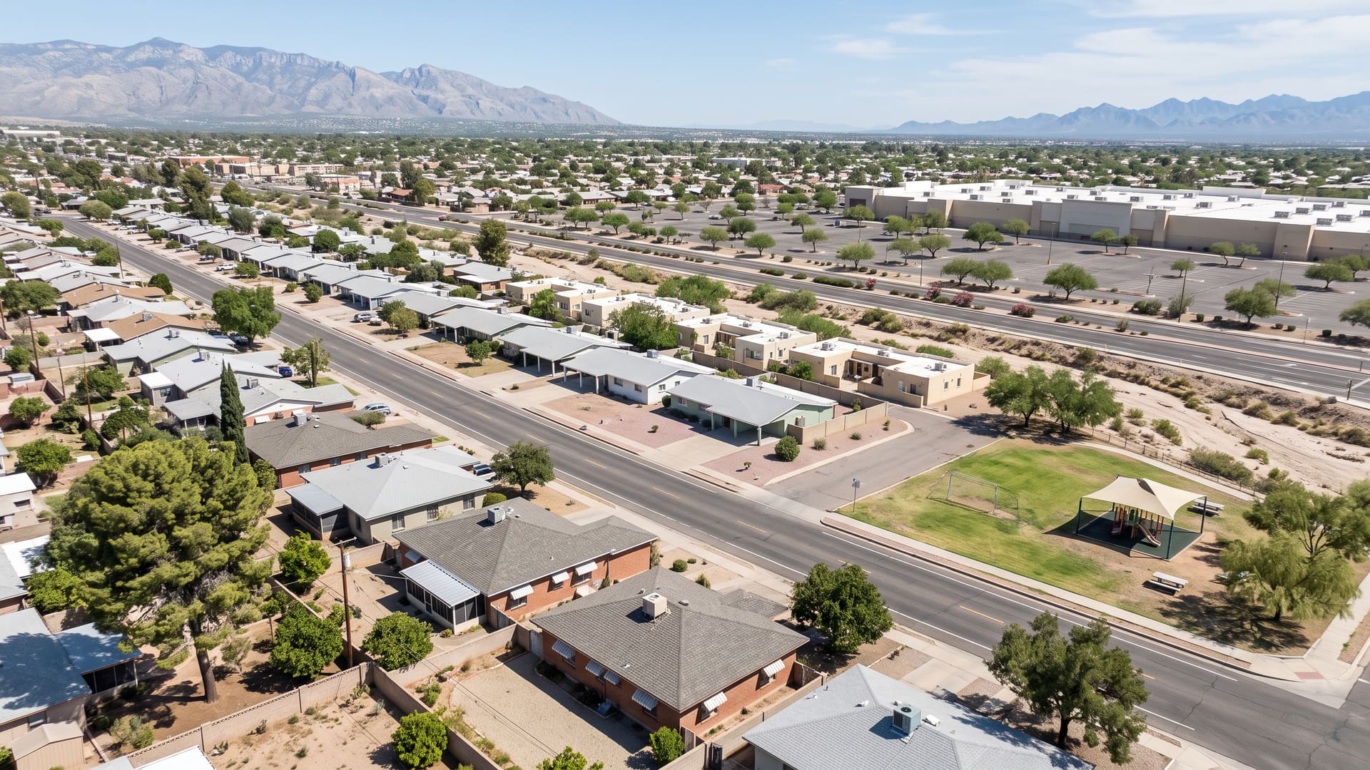
Colonia Del Valle Homes for Sale — Tucson, AZ
Colonia Del Valle is a rectangle of east-central Tucson in ZIP 85711, bounded by Craycroft Road on the west, Wilmot Road on the east, 22nd Street on the south and East 14th Street on the north, where every recorded subdivision plat was filed between 1948 and 1957 and the last three years carried 75 closings at a $335,000 median.
Key facts
- Jurisdiction
- Tucson, Arizona — incorporated city, Pima County
- Average sale price
- $335,000
- Price range
- $250K – $400K
- School district
- TUSD (Kellond Elementary, Vail Middle, Rincon High)
- Approximate population
- ~2,000
- Approximate number of homes
- ~980 homes
What defines this area
- Mesa Village Park, a City of Tucson municipal park inside the boundary
- Park Place immediately north across East 14th Street
- The Murphy-Wilmot Library seven tenths of a mile out
- Tucson Fire Station 9 standing inside the boundary on Wilmot Road
- Craycroft Road west, Wilmot Road east, 22nd Street south, 14th Street north
- The southern two thirds of a survey section, 358 acres in all
- Eleven recorded plats, every one filed between 1948 and 1957
- R-1 zoning on 905 of its 1,014 parcels
- Seventy-one of 75 recent closings detached, four attached, none condominium
- Detached closings built to a median year of 1958
- Living areas 800-3,175 sq ft, median 1,563
- A $335,000 median against a $335,362 average across the 75
- Arcadia Wash crossing it in its one earthen-banked reach
- Inside the Davis-Monthan Air Force Base Vicinity disclosure territory
- Wholly inside the City of Tucson, in Ward 6 and in ZIP 85711
About Colonia Del Valle
Colonia Del Valle is a rectangle of east-central Tucson in ZIP 85711, bounded by Craycroft Road on the west, Wilmot Road on the east, 22nd Street on the south and East 14th Street on the north, where every recorded subdivision plat was filed between 1948 and 1957 and the last three years carried 75 closings at a $335,000 median. Three of those four streets do double duty. Craycroft, Wilmot and 22nd Street are the west, east and south lines of Section 13, Township 14 South, Range 14 East, and all three run within a few metres of where the county maps its own road centreline. What the rectangle does not do is reach the section's north line at Broadway. It stops on East 14th Street, an ordinary residential street about two thirds of the way up, so the boundary covers the southern two thirds of a survey section and no more. Measured off the mapped outline that is 357.5 acres, in a box a mile wide and seven tenths of a mile tall which it fills to about four fifths. The missing fifth is a corner in the north-west, and it belongs to a neighbour rather than to nobody. Its edges are shared with the neighborhoods beside it rather than cutting across them. Section 24, the full square mile directly south across 22nd Street, is Corbett, and the two boundaries run on the same line, vertex for vertex. East across Wilmot Road is Palo Verde Park, which runs on to Kolb Road. Both are pages on this site. The name is three things at once, and all three agree. It is a subdivision plat, recorded in June 1948. It is a neighborhood association, registered with the City of Tucson in January 2002 and listed as active in Ward 6. And it is a pair of streets: South Colonia Avenue and South Del Valle Avenue run north and south through the middle of the boundary, two blocks apart. Plat, register and street sign all agree, which is not the usual case. The boundary is that association, very nearly to the metre. Tested cell by cell against the City's own filed outline it agrees on 99.5 per cent of the ground, and the half per cent that differs is all edge. Sample the interior on an even 65-point grid and every single point comes back Colonia Del Valle and nothing else. Four other associations touch the line and cover no interior point at all. The corner the boundary gives up belongs to the association next door. Wilshire Heights registered with the City in March 1981 and holds about 65 acres above the Wilshire Drives, between Craycroft Road and the block west of South Colonia Avenue. The Colonia Del Valle association excludes that ground and so does the boundary these figures are aggregated over, so nothing on this page describes it. It has no page here. What is inside the line was platted inside a single decade. Eleven recorded subdivision plats lie wholly within the boundary and every one of them was filed between June 1948 and November 1957, nine and a half years end to end. Colonia Del Valle came first, in June 1948. The county records 96 lots against that filing, but its mapped polygon is the largest of the eleven at about 101 acres and carries closer to three hundred parcels today. Read the 96 as what was recorded in 1948 rather than as what stands there now. Mesa Village Estates followed with 144 lots in April 1952 and Mesa Village Annex with 40 that August. San Fernando Village was filed twice, as two adjoining bands of about 38 acres each carrying 148 lots apiece, in May 1954 and April 1955. Douglas Terrace came in two parts in 1954, 69 lots in September and 38 in December. Then Sharon Addition with 34 in June 1955, Bryant Addition in February 1957, Sharon Addition No. 2 with 20 in May 1957 and Vomaska Addition with ten in November 1957. Two further plats cross the line without lying inside it, and both of them are in the Wilshire Heights corner. Those eleven cover a little over three quarters of the boundary; most of what they do not cover is arterial frontage on Craycroft, Wilmot and 22nd Street that was never cut into lots. That compression is the most useful thing to know about buying here. One generation built almost all of it, to a median year of 1958. The house across the road is usually the same vintage as the one you are looking at, and often close to the same size, so a comparable sale here is easier to trust than it is on a street that filled in over fifty years. Every one of the 1,014 parcels inside the line is City of Tucson, and the zoning is unusually uniform for midtown. R-1, the City's lowest-density residence zone, covers 905 of them, a shade under nine in ten, which is why an interior block here is detached houses and nothing else. Behind it come 49 C-1, 33 R-2, 15 C-2 and 12 O-3. Every commercial and office parcel fronts Craycroft, Wilmot or 22nd Street and none of them is interior, so a garden wall a lot or two in from one of those roads can be the far edge of a parking bay. The R-2 parcels are scattered singly rather than gathered into a district of their own. What sells inside the line is one kind of house. Across the three years to September 2026, 75 homes closed here: 71 detached, four townhouses and no condominium at all. The detached tier was built to a median year of 1958 on a record running 1951 to 2010, measured 1,610 square feet at the median and closed at $339,000, which works out to $200.99 a square foot. The four townhouses were all built in 1971, ran 1,053 square feet and closed at a $246,350 median — four sales is too thin to read as a second tier, and it is reported here rather than relied on. Blend the 75 and they span $141,000 to $650,000, with a $335,000 median, a $335,362 average and a $335,000 list median. The average and the median are the same figure to within four hundred dollars, about a tenth of one per cent apart. That is what a single market of comparable houses produces. Where a boundary holds two markets, or one very large sale, the average pulls away from the median instead. Little of it sat. Half the listings were under contract inside 21 days, 22 once relists are counted, and the record settled at 98 cents on the list dollar; 19 of the 75 went above asking and 27 dropped their price first. Both of those day counts were computed from 73 listings rather than all 75 — a field count short of the total, not a smaller set of sales. The band at the top of this page is the thick middle of that spread rather than its ends. Fifty-three of the 75 closed between $250,000 and $400,000, ten under it and twelve over. Three of the ten went below $200,000 and the dearest of the twelve took $650,000. The watercourse to ask about is Arcadia Wash, and it looks different here from the way it looks upstream. Pima County's regional flood control record maps four reaches of it, and only the southernmost runs through this boundary — the one reach of the four left with earthen banks rather than lined in grey soil cement. It crosses the western side on a diagonal, passes the edge of Mesa Village Park and leaves at 22nd Street. The regulated setback the county puts on the named channel here is 50 feet, with three narrower channels carrying 25 feet each. A setback is measured out from a mapped channel rather than from a property line, which makes it a question about a parcel rather than about a neighborhood. The same wash runs on north through St. Cyrils, where every mapped reach of it is lined, and that page is on this site. A military airport disclosure attaches to this ground, and the installation behind it is close. The mapped perimeter of Davis-Monthan Air Force Base is nine tenths of a mile off the south-west corner, and all 65 sample points fall inside the Davis-Monthan Air Force Base Vicinity layer Pima County publishes. Two statutes are doing the work. Arizona Revised Statutes section 28-8461 fixes that territory leg by leg rather than as a radius. This boundary sits on the leg it runs six and a half miles out, perpendicular to the runway centreline on the base's north-east side. At nine tenths of a mile, then, this is not ground near the edge of the territory. It is well inside it. Section 28-8484 is the obligation: a seller of residential property inside that territory owes the buyer a written disclosure before title passes. The same section ties the territory to a map the State Land Department draws under section 37-102, which is a different document from the county layer. Treat the county layer as notice that the question is live and the state map as the answer for a particular address. Six further mapped layers cover none of this boundary at all: the base's noise control districts, its Air Installation Compatible Use Zone, the Tucson Airport Authority's avigation easement and disclosure area, and the county's three airport environs overlays for height, land use and noise. Those six were then run a second time over the base itself and a third time over Tucson International, and returned features at both, so the blanks here are emptiness and not a query that failed. An avigation easement recorded against one particular parcel is a separate matter again; it is a title question, and it surfaces in the commitment. Tucson Unified takes the whole boundary, and the assignment is the same at every point in it. Kellond Elementary School, Alice Vail Middle School and Rincon High School come back at all 65 sample points; LiveBy's own assignment query over the boundary names those three and stops there, so the county record and the MLS record match campus for campus. All three stand outside the line. Vail Middle is closest, an eighth of a mile west on East 16th Street across Craycroft Road; Kellond Elementary is a little under half a mile east, and Rincon High about a mile and a quarter to the north-west. Assignments are drawn by address and they change, so confirm the assignment for a specific address with the district before relying on it. The public ground inside the line comes to two properties. The first is Mesa Village Park, 2.4 acres the City of Tucson keeps at 5700 East 18th Street, equipped with a playground, a multi-purpose field, picnic tables, grills, benches and a drinking fountain, and with no ramada and no restrooms. The second is Tucson Fire Station 9, on the eastern edge at 730 South Wilmot Road. The county maps no shared-use path anywhere inside the line; what its bicycle layer does carry is an open on-street route the length of Craycroft Road, along the western edge. Everyday logistics are simple. Address and government are both undivided here: every one of the 1,040 county address points inside reads 85711, and Ward 6 comes back at all 65 sample points. The nearest shopping is nearer still: Park Place, an enclosed regional mall, stands immediately north across East 14th Street, its mapped edge about fifty feet from this boundary's own. The Murphy-Wilmot Library is seven tenths of a mile out. Further afield: El Con Center 2.3 miles, Tucson Medical Center 2.4, the Reid Park Zoo 2.5, the Tucson Botanical Gardens 3.0, Pima Community College's East Campus 3.5, the University of Arizona 4.2, Banner – University Medical Center Tucson 4.5, downtown Tucson about 5.4 and Tucson International Airport 6.3.
Colonia Del Valle is a suburban neighborhood in the City of Tucson, on the central side of metro Tucson, Arizona, served by TUSD (Kellond Elementary, Vail Middle, Rincon High). Homes trade in the $250K – $400K range, with an average sale price of $335,000 across roughly 980 homes and a population of about 2,000. Kyle Berglund, REALTOR® at Tierra Antigua Realty, represents buyers and sellers here — call (520) 250-8904.
Compare nearby Tucson neighborhoods
- Corbett — Affordable, average $278,000
- Palo Verde Park — Affordable, average $305,000
- St. Cyrils — Urban, average $303,000
- Vail — Suburban, average $421,000
- Downtown Tucson — Urban, average $400,000
- Midtown Tucson — Urban, average $350,000
- Tanque Verde — Suburban, average $560,000
- Sam Hughes — Urban, average $650,000
Frequently asked questions
What city is Colonia Del Valle in?
Colonia Del Valle is in the City of Tucson, Arizona. Jurisdiction: Tucson, Arizona — incorporated city, Pima County.
What is the average home price in Colonia Del Valle, Tucson?
The average sale price in Colonia Del Valle is approximately $335,000, with homes generally ranging from $250K – $400K. These are rounded, long-run estimates aggregated from MLSSAZ closed sales through the LiveBy data connection, over this neighborhood's own boundary, for general orientation — not a current-month figure. Averages are means and can be skewed by a small number of high-value sales, so individual home values vary materially.
What school district serves Colonia Del Valle?
Colonia Del Valle is served by TUSD (Kellond Elementary, Vail Middle, Rincon High). Confirm exact school assignments by specific address, as boundaries can change.
Is Colonia Del Valle a good place to live?
Colonia Del Valle is a suburban neighborhood in the City of Tucson, on the central side of metro Tucson, Arizona, known for Mesa Village Park, a City of Tucson municipal park inside the boundary, Park Place immediately north across East 14th Street, the Murphy-Wilmot Library seven tenths of a mile out, Tucson Fire Station 9 standing inside the boundary on Wilmot Road. Colonia Del Valle is a rectangle of east-central Tucson in ZIP 85711, bounded by Craycroft Road on the west, Wilmot Road on the east, 22nd Street on the south and East 14th Street on the north, where every recorded subdivision plat was filed between 1948 and 1957 and the last three years carried 75 closings at a $335,000 median. It has an approximate population of ~2,000 across roughly ~980 homes.
What kind of homes are for sale in Colonia Del Valle?
Colonia Del Valle is a suburban submarket where homes generally trade between $250K – $400K, with an average sale price of $335,000.
Who can help me buy or sell a home in Colonia Del Valle?
Kyle Berglund, a licensed Arizona REALTOR® (License #SA668710000) at Tierra Antigua Realty, specializes in Colonia Del Valle and the greater Tucson area. Call (520) 250-8904 or email contact@kyleberglund.com for a free consultation.